Since 1763 the name 'Russborough' has been synonymous with collecting and dealing in fine art. In the closing decades of the last century the historic town of Port Hope has become home to Lord Russborough's Annex, which specialises in an individual mix of antique maps, paintings and prints.

While Lord Russborough's Annex features a great many works of museum calibre, we also offer a wonderful selection of prints priced at under $100.

sect 13 Arctic knowledge advances sect image
SECTION 13
 ARCTIC KNOWLEDGE ADVANCES: Meteorological Observation and Phenomenon

Whalers who had been probing the ice pack since the 16th. century were swift to take advantage of the increase of ice free waters coinciding with a climate change which caused the ice surrounding Greenland, which had been ice bound for four centuries, to break up [See section 4]. Vast quantities of ice and bergs were observed in the north Atlantic in 1817. Following the cessation of the Napoleonic wars, sailors of various European nations and those of Russia began to explore arctic waters. Feodor Litke thoroughly mapped the west coast of Novaya Zemlya in 1821-1824 and carried out geographical and hydrographical investigations. In another expedition between 1821 and 1824, Feodor Wrangel and F. Matyushkin described hundreds of miles of Siberian coast. Britain outfitted ships for two arctic explorations commanded by Capt. John Ross, Lt. Wm. Parry and Capt. John Buchan, Lt. John Franklin respectively [See section 10]. Whalers, especially those of a scientific bent, such as William Scoresby Snr. and William Scoresby Jr. [Sections 3&10] made arctic meteorological observations. Also among them, was the Irishman Bernard O’Reilly, a natural philosopher and explorer of highly dubious repute, who embraced the bandwagon of electro-magnetism and other aspects of Natural History. O'Reilly claims to have discovered the Linnaean Island Chain (North-west of the Devil’s Thumb) and was confident of the discovery of a northwest passage. Although O'Reilly made many of the observations in his book “Greenland and its adjacent seas….”, it is believed that large parts of the text were plagiarized from the lectures of Professor von Gièsecke. Elsewhere in North America settlers were being brought to the Red River country via the Hudson’s Bay Company ships along with supplies for the newly amalgamated (1821) H.B.C. & N.W.Co. forts and trading posts. (See section 9)
In Italy, Dr. Giulio Ferrariopublished his influential multi - volume “Il costume Antico e moderno, o Storia del governo, della milizia, della religione, dello arti, scienze ed usanze di tutti i popoli antichi e moderni provata coi monumenta dell' antichita e rappresentata cogli analoghi disegni.” Milan 1827, which included observation on the natives and customs of the Greenland Eskimos.

References cited or consulted:
O’Reilly, Bernard. Greenland, the adjacent seas, and the North-west Passage to the Pacific Ocean, illustrated in a voyage to Davis's Strait, during the summer of 1817. ... London, Baldwin, Craddock and Joy, 1818.
Ferrario, Dr. Giulio  Il costume Antico e moderno, o Storia del governo, della milizia, della religione, dello arti, scienze ed usanze di tutti i popoli antichi e moderni provata coi monumenta dell' antichita e rappresentata cogli analoghi disegni. Milan 1827,
Giésecke Charles L. On the Noregian Settlements on the Eastern Coast of Greenland, or Osterbygd, and their situation. Transactions of the Royal Irish Academy Vol.14 (1825) pp.47-56

The relevance of Arctic meteorological observation

  • As exploration across the Polar sea and surrounding Arctic coastline increased, the study of the scientific phenomena observed made its way into journals other than just the published accounts of the voyage. These findings were made use of by sailors of all nations.
  • The increasing number of icebergs observed by whalers in the North Atlantic since 1817 led them to conclude that climate change was a reality.
  • Bernard O’Reilly laid claim to the discovery of the Linnaean Islands.
  • Knowledge of the customs of Arctic natives was disseminated throughout Europe and Russia.


PLEASE NOTE THAT THESE ITEMS MAY ONLY BE PURCHASED AS A COMPLETE SECTION

 Six Items >DANN           PRICE CODE E             Contact us              

disco at fortune bay

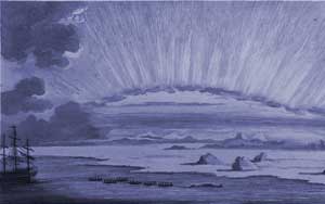
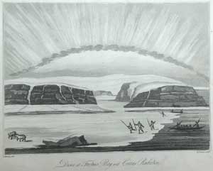
DISCO AT FORTUNE BAY WITH CIRRUS RADIATION
 Frederick Christian Lewis after S. Koenig
 Aquatint.  7 3/16 x 8 ½”  (18.2 x 21.5 cm.)
Ref. LRAarc133 /AL/ l.dnsv > DNN

Published in Bernard O’Reilly “Greenland, the adjacent seas, and the North-west Passage to the Pacific Ocean, illustrated in a voyage to Davis's Strait, during the summer of 1817. ...” London, Baldwin, Craddock and Joy, 1818.

Depicted are two large boats paddled by native Greenland Inuit, which have landed at some shore ice in Fortune Bay.  Inuit with spears, appear to be in pursuit of two bears. The layered strata of the rocky coast are in evidence.  The cirrus clouds were made of ice spheres that reflected solar radiation. Much taken by the formation of clouds, on the subject of which, O’Reilly had undertaken considerable reading. This meteorological observation was made on Disco Island off the western coast of Greenland. The voyage was made by the whaling ship Thomas (William Brass, Master) out of Hull, on 8 March 1817 with O'Reilly serving as ship's surgeon.
Title page states that the plates are taken from drawings done by the author on the spot.

Linnaeanislands

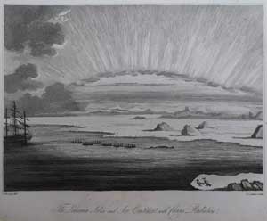
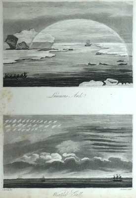
THE LINNÆAN ISLANDS  AND ICE CONTINENT WITH CIRRUS RADIATION
Frederick Christian Lewis after S. Koenig
 Aquatint. 6 ¼  x 7 7/8”  (15.8 x 20 cm.)
Ref. LRAarc106 /AN/ l.dnsg > DNN

Published in Bernard O’Reilly “Greenland, the adjacent seas, and the North-west Passage to the Pacific Ocean, illustrated in a voyage to Davis's Strait, during the summer of 1817. ...” London, Baldwin, Craddock and Joy, 1818.

 “July 16th.  The ship advancing towards land on a S.E. course, came in with an extensive field of ice reaching to the Linnæan Isles: this field was interspersed with numerous bergs, and appeared  unbroken for leagues in extant east and west. The state of the cloud this day, beautiful cirrocumulus, and flimsy comoid cirrus, the points of which were scattered in every direction.” O’Reilly p.194.   In this view five of the Thomas ships’ boats are seen, one of them towing a whale toward the ship at the left. The Linnæan islands were observed to be about seven miles away.
A pair of Greenland Doves (Colhmbus grylle) is depicted in the right foreground.

Sect13luninusarch

LUMINOUS ARCH
WEATHER GALL
Frederick Christian Lewis after S. Koenig
 Pair of Aquatints. 9 5/8 x 6 ¼” (25.5 x 15.7 cm.) pair. 
Ref. LRAarc105 /AN/ l.dnsg > DNN

Published in Bernard O’Reilly “Greenland, the adjacent seas, and the North-west Passage to the Pacific Ocean, illustrated in a voyage to Davis's Strait, during the summer of 1817. ...” London, Baldwin, Craddock and Joy, 1818.
“A luminous arch appeared this afternoon in opposition to the sun, but destitute of iridescence: the whole interior of this arch was strongly luminous, and objects within its compass partook of that illumination.” O’Reilly p.196    The whaling ship Thomas and three of its shallops approach a pod of whales. A seal lies on the foreground ice.
A bank of fog rolling in, forming a weather gall over the horizon, its dramatic appearance resulted in a “display of cirrocumulus, resting apparently on cirro-stratous beds which had previously formed in an elevated position.”  O’Reilly p.202

Sect13greenlandhomes

ABITAZIONI DE GROELANDESI  [Greenland homes]
Published in Dr. Giulio Ferrario “Il costume Antico e moderno, o Storia….” Milan 1827 America Vol 7 p.182
Hand coloured aquatint engraved by Gallo Gallina
 6 ¾ x 11” (7.2 x 28 cm.)
Ref. LRAarc154 /RN/r.dnss > DNN

“The Greenlanders have tents for the summer and houses these are about four feet high the walls are of stone and peat and support a bed placed tulle on one side are closed with lists of marine and other sea fish so transparent and allow the light without giving rise to the wind. The walls and the attic are lined with old leathers attached with nails made of sea calf hides they protect from humidity. The entrance to the house is so low that he has to crawl to enter and this is made to shelter from the wind and cold. Each building contains from three to ten families and each family has its own living room the house divided with several planks. In front of the windows are placed the benches one foot from the ground and covered with skins on which one sits down and sleeps. Each apartment has its own fire and this is how a large log is placed against the separation table and above this a flat stone that supports a treppiè, with a half-moon-shaped marble lamp one foot wide and encased in a vase oval alloy placed there to receive the oil that drips from it. This has a fine moss for its wick, which brightens and warms the house, above the lamp hangs a bowl of copper or stone ordinarily one foot long and six inches wide in which food is cooked. At the same fire, clothes and boots spread over a species are placed to dry.” p.183

Vide Sabin 24164

vyagesrossparryfranklin

CHART ILLUSTRATIVE OF THE VOYAGES AND TRAVELS OF CAPTAINS ROSS, PARRY AND FRANKLIN
 W.R. GARDNER Engr.

First Edition. Published by C. Smith, London, April 1824 for Smith’s New General Atlas.
Plate size: 12 x 14 ¾” (30.5 x37.5 cm)
Ref.LRA1173/DRL/l.dnsv >LNN

This is the first edition of this map. Shown are the early European explorations of North America and Greenland and by colour code, those of Ross 1818 (blue); Parry 1819-20 (red); Franklin 1819 & 22 (green); Parry 1821-23 (yellow) with explanatory notes and data in text blocks lower right and left. The explorations of Hearne and Mackenzie are also delineated.
Also of interest are the many place names along the coasts of Greenland, the nomenclature of which came from native Greenlanders, European whalers and Vikings. Worthy of note is that of Julianas habb (Julianehåb) today Qaqortoq, immediately to the north of which was situated the Old Norwegian Viking settlement of Tessermiut and East Greenland which is named ‘Scoresby land 1822’.    

To purchase the original antique Maps and Prints of section 13 Contact us

© Darrell G. Leeson MMXXI