|
|
|
|
 |
|
 |
“Never in the thirty years at sea have I seen two ships so close to destruction” La Pérouse. July 1786
SECTION 6 THE TRAGIC VOYAGE OF La PÉROUSE
Having built a reputation gained during the American War of Independence, during which Jean-François de Galaup, Comte de la Pérouse (23 August 1741 – 1788?) who’s distinguished naval career positioned him as something of a nemesis of the British, following an attempt to gain control of Newfoundland, engagement at Louisbourg, another off St. Kitts. And the sacking of the H.B.C. forts in Hudson Bay. (See Section2 )
Commodore La Pérouse was commissioned by Louis XVI of France to command a round-the-world voyage of discovery in 1785. The purpose the La Pérouse voyage of exploration was to fill in some of the gaps in the charting of the world following Cook's voyages (the latter La Pérouse greatly admired) and prove that Frenchman could also be world class explorers. Thus, he was to seek a North West Passage from the Pacific, and explore the coasts of the
Pacific northwest, before proceeding to the Far East and the South Pacific Islands.
How the history of Europe might have been changed had not the application of one potential crewmember been denied, that of sixteen-year-old Corsician Lt. Napoleon Bonaparte.
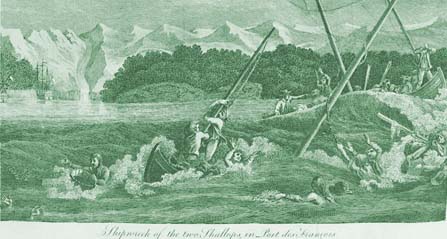
On 23 June 1786 the two frigates ‘La Boussole’ and ‘L’Astrolabe’ were in sight of Mount St. Elias, and entered Port Des Français, today's Lituya Bay, Alaska, on 2 July. While making a survey of the bay, six officers and 15 crew members were lost in a storm.
Sailing south along the North American coast the well-equipped voyage of discovery, which included a 1,200 volume library, weather balloons and some of the latest scientific, instruments, explored the western Pacific during 1787. He became the first European to set foot on Maui. Sending several reports and charts of their progress back to France en-route. In October 1787 La Pérouse had also sent a Russian-speaking officer, Jean Baptiste Barthélemy, Baron de Lesseps (1766-1834) overland from Kamchatka with documents, charts, and journals. De Lesseps traveled through Siberia to St. Petersburg and then to Paris, arriving late in 1788.
|
 |
|
 |
|
|
|
|
|
 |
|
 |
In 1788, after visiting the convict settlement in Botany Bay, Australia they departed and were never heard from again.
As he mounted steps leading to the guillotine, Louis XVI is said to have asked “Have we any news of Monsieur Lapérouse?” Such concern moments before his death testify to the immense importance that the King of France accorded to the expedition.
In May 1791, when it seemed clear that La Pérouse would not return, the revolutionary government commissioned former army officer Louis Antoine Milet-Mureau (1756-1825) to edit a book from these materials, which was published in Paris in four volumes with an atlas in 1797. A second French edition was required the following year, and English translations appeared in 1798, 1799, 1801, and 1807; German and Dutch editions were published between 1799 and 1804.
An Irishman, Peter Dillon in 1926 purchased some swords in Tikopia, Solomon Islands and was able to establish that they had come from one of the wrecked ships but it was to be a hundred and seventy-six years after their loss that the wreckage of the two ships was discovered on Vanikoro reef east of the Solomon Islands. One of the foremost navigators of his age, La Pérouse did much to contribute to scientific knowledge.
REFERENCES CITED:
Sabin Bibliotheca Americana, A Dictionary of Books relating to America. New York, 1868-1936.
Wagner, H.R. the Cartography of North-West America to the year 1800. Berkley 1937
Cook, A., Holland,C. The Exploration of Northern Canada 500-1920 A chronology. Toronto 1978. 1785-88
https://qmackie.com/2010/02/22/la-perouse-at-port-des-francais-lituya-bay
|
 |
|
 |
|
|
|
|
|
 |
|
 |
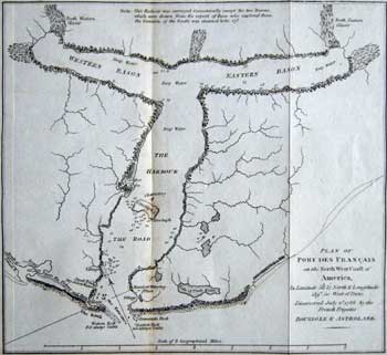
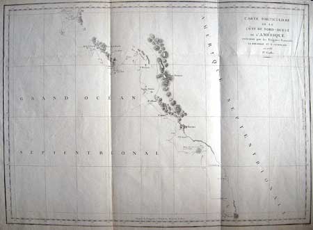
[La PÉROUSE]- Lituya Bay
PLAN OF PORT DES FRANÇAIS on the north west coast of America,…Astrolabe.
[La PÉROUSE?] [London 1799]
Original Copper engraving on wove paper.
7 7/8 x 7 ½ (17.5 x 18.9 cm) Ref.LRA 1081/De/o.dosl> ANN
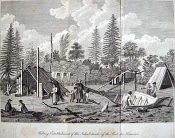
Published in the atlas accompanying Voyage de la Pérouse Autour du Monde, in the years 1785, 1786,1787 and 1788 London: Printed for J. Johnson, St. Paul's Church Yard., 1799, this is a reduced English version of the chart of Port Des Français present day Lituya Bay, Alaska, showing the anchorages of the French frigates, soundings, Indian village and topographical features. This area was visited in July 1786, by La Pérouse who was the first European to discover this bay; he “bought it” from a local native American chief and claimed it for France. The explorer established what is widely believed to be the first face-to-face contact between Europeans and Tlingits. La Pérouse’s impressions of those encounters, notable for their peacefulness, are described in detail in his journals, which have become a heavily quoted historical resource.
Port des Français is the only haven for seafarers facing the open sweep of the Pacific on the passage north from Cross Sound to Yakutat. La Pérouse recommended that France establish its base in Alaska at Port des Français, which he described in his journal as “perhaps the most extraordinary place in the world.” Tragically on July 13, 1786, La Pérouse’s “calm waters” suddenly swallowed up a barge and two longboats carrying 21 of his finest officers and men as they attempted to sound the waters in the extremely strong tidal currents at the entrance to Lituya Bay. None of the bodies were recovered.
This site with its potential for terror is probably best known for the earthquake-caused tsunami on July 8, 1958, the first wave of which reached a height of some 1,720 feet, said to be the biggest wave ever recorded.
Ref. Sabin 38963
|
 |
|
 |
|
|
 |