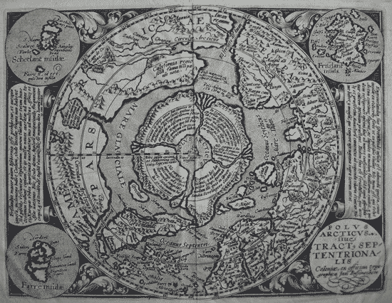
POLUS /ARCTICUS/ siue /tract, Sep/tentriona/lis. Coloniae, ex Officina Typographica Jani Bussemechers
insets:Farre insulæ
Schetlant insulæ
Frisslant insula
SCARCE. Original copper engraved map on laid paper. Uncoloured as issued. Latin text on verso.p.81 good impression good condition and borders.
8 3/8 x 10 7/8’“ (21.2 x 7.6 cm.) Ref. LRA1169/OLN/a.dosv> DONN
Published by Iohan Buxemacher. Cologne [1600 (1608)]
This important early map of the North Polar regions by Quad is a reduced version of the first state of Mercator's landmark map of the Arctic from 1595. Nova Zemla is drawn as an archipelago, the islands disappear in the second Mercator edition.The magnetic North Pole is shown, according to legend, as a separate island rock, just outside the polar mass, surrounded by four islands that are separated by rivers, which draw to it via the four rivers all the waters of the northern seas whence they descend in a giant whirlpool to the center of the earth. (This idea was promulgated in a letter dated 1577 from Mercator to John Dee, Astrologer the Queen Elizabeth I and one of the foremost scientists and geographers of the period, The origin of the legend being derived from a lost tract of Martin Behaim 1492 'Inventio Fortunata' which described the visit of an English minorite/greyfriar to the Viking east Greenland settlement in Ca. 1450. This Scandinavian concept was incorporated into European maps via Dr. John Dee and Mercator.
In North America is a very early reference to California (California regio, sola fama Hispanis nota), curiously shown north of the El streto de Anian. The map depicts the attempts of Frobisher (late 1570's) and Davis (1585) to locate the northern passages to Asia.
In the Canadian Arctic, amongst other details, two rivers and a sweet water sea are depicted; this may be the first depiction of the Coppermine River and Hudson Bay, if so they predate the Gerritsz-Hudson map by 20 years.
The main map is surrounded by a floral design and strap-work panels with four roundels in each corner. These contain the title, the Faeroe Isles, the Shetland Isles, and the mythical island of Frisland. Two panels of text have been added with a brief commentary on both Frisland and Greenland.
Matthias Quad von Kinckelbach 1557-1613 was a map publisher based in Cologne, Germany. but had lived and was trained in the Netherlands. He was a well-travelled and accomplished cosmographer and geographer. Born in the Netherlands of German parents in 1557, he likely became familiar with the work of Ortelius, De Jode, and Mercator in his early years there. In the mid 1500's the map-making and publishing business began to be dominated by the Dutch who not only dominated trade in western Europe, but also had perfected the art of coper engraving (over wood cut engraving of the Italians and Germans). Quad became acquainted with the illustrious Doetechum family of engravers in his home town of Deventer. He was further schooled in Germany and settled in Cologne. He worked with many in the flourishing printing trade there, most notably under Franz Hogenberg. His first atlas was Europae...Descriptio of 1592 with 38 maps, expanded to 50 maps in 1594. This was expanded again in 1600 to this Geographisch Handtbuch with 82 maps. These books were both smaller pocket atlases intended to be less expensive alternatives to the larger folio atlases of Ortelius, Mercator, and De Jode, which also provided the source maps for Quad's atlas maps. Quad embellished his maps with scenes, portraits and other illustrations that make them rather unique. The Geographisch Handtbuch was the first atlas originally written with German text. Quad also produced larger single sheet maps, including a map of Europe in the form of a Queen (1587) and city plans for the Braun and Hogenberg Civitates Orbis Terrarum. In 1608 Quad published a third atlas with 86 maps, Fasciculus Geographicus.
References: Burden, P.D. The Mapping of North America, no.134.; Meurer, P.H. (Cologne) Qua 79.
Kershaw K.A. Early Printed Maps of Canada 1530-1703 vol 1 34 pl 21
Home | Contact | Location | Links | Antique Prints | Fine Art | Antique Maps | Omnium Gatherum | Specialty Services

