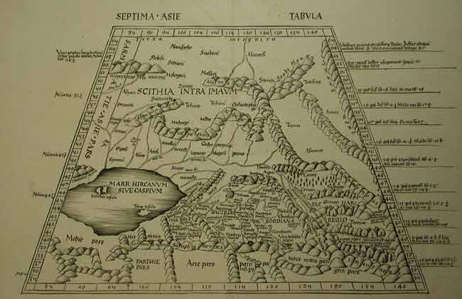
THE RARE SEVENTH MAP OF ASIA FROM THE 1513 STRASSBURG PTOLEMY
PTOLEMY/ SCHOTT- Central Asia Turkistan
SEPTIMA ASIA TABULA
Claudius Ptolemæus [Martin Waldseemüller] Johannes Schott, Strassburg 1513
RARE. Uncoloured woodcut, excellent condition.
13 ½ x 21 ¾” (34 x 53.3 cm.) including title. Good margins.
Ref. LRA775 /ALN /v.vs >ROOL
A fine clear map of the ancient ‘Silk Road’ published in the 1513 edition of Ptolemy’s Geographica depicts the classical view of Central Asia and Turkistan, with a horizontal delineation of the Caspian Sea. Turkistan, the mystical land of Samarkand, was the fartherest known reaches of the world, as known to Ptolemy. Shows the mountainous area of Pamir and Imaus in the east, with the trade routes through the tribal areas of Bactria and Sogdiana with Scythia to the north and the Caspian Sea to the west. “This complex territory constituted the Silk Road, a network of overland trails from China to the Mediterranean. Embracing parts of today’s Iran, China, India and the central Asian countries of the former Soviet Union, mysteries about the region’s geography and ethnology persisted until the end of the nineteenth century” Vide: Nebenzahl, Mapping the Silk Road, p.16. The map is in excellent condition save for two small wormholes through the lower border and is typical of the boldly executed woodcut maps by the hand of Walseemüller .
Based on the knowledge gathered slowely over four thousand years and housed in the great library of Alexandria, Ptolemy, during the second century AD., produced what is considered one of the landmarks of geography. His influence is still felt today, as it was he who introduced the words Latitude and Longitude to cartography. But his major work the Geographia was forgotten in the west with the movements of the German tribes and the beginning of the ‘Dark Ages’. From the Renaissaince until the sixteenth century, Ptolemy’s Geographia, in various editions remained the most important work of geography in existance.
The 1513 Strassburg edition of the Geographia edited by Martin Walseemüller (begun in 1505), is considered to be the most important edition of Ptolemy due to the former’s scholarship of surviving Ptolemaic sources, it contained 27 maps of the ancient world, drawn on a trapezoidal projection, to which were added 20 modern maps based on contemporary knowledge. The Saint Dié geographer Walseemüller collaborated with Mathias Ringmann (until the latter’s death in 1511) and between them they produced what some scholars term the first ‘Modern’ Atlas. It was in this edition printed by Johannes Schott in Strassburg 1513 that the first map specifically devoted to the New World (Tabula Terra Nova) appeared.
It was Waldseemüller who attached his friend Amerigo [Vespucchi ] name to the New World or the ‘India’ discovered by Columbus.
Vide: Sabin, J. Bibiotheca Americana, #66478
Phillips,L.P. A list of Geographical Atlasses in the Library of Congress. # 359
Nordenskiöld, A.E. Fascmilie-Atlas to the early history of Cartography NY. 1973 #11
The World Encompassed #56
Home | Contact | Location | Links | Antique Prints | Fine Art | Antique Maps | Omnium Gatherum | Specialty Services
