JOHN STRUT
1658-1730
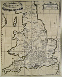
BRITANNIA SAXONICA
Copper engraved map title cartouche (upper left), milage scale and key to lettering and symbols (upper right). Uncoloured as issued in Camden's Britannia 1695 within a checkered border.
14 3/4 x 11 5/8" (37.5 x 29.5 cm.) Ref. PS24 /ann/ s.nl >LOL PRICE CODE C
A fine piece of early English printing using a Celtic font and old English spelling, showing Saxon Britain under the Heptarchy places of pilgrimage, monasteries, cathedrals, battles topographical features some place names, long boats and other period shipping and Hadrian's wall are delineated. The map was drawn by Robert Morden, engraved by John Sturt.
Home | Contact | Location | Links | Antique Prints | Fine Art | Antique Maps | Omnium Gatherum | Specialty Services
