![]()
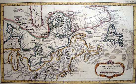
LA NOUVELLE FRANCE OU CANADA
[Jacques Nicolas Bellin] [Paris 1764]
SCARCE Original copperplate map Original hand tinted outline colour. Rococo title cartouche. Double matted, glazed, gilt-wood frame,
Map:7 ¾ x 13 ¾" (19.8 x 34.8 cm.) Frame: 17 ½ x 22 ½"
Ref. TM2 / DNN/ r.andg> ENN PRICE CODE B SOLD
Published in Bellin J.N. Le Petit Atlas Maritime Paris 1764 Vol. /Tome 1 #4 Shows an early 18th cent. delineation of Newfoundland and the Great Lakes based on loosely on the De L’Isle outlines. Depths are shown by soundings in the Grand Banks as are the locations of a number of the strategic French Forts erected during the Seven Years War. The map shows the territories of New-France or Canada on the eve of the signing of the Treaty of Paris, The territories then being transferred to British rule.
SCARCE This is only issue of this version of Bellin's map, which slightly larger than the more commonly found version.
Jacques Nicolas Bellin (1703-1772) was one of the most important and proficient French cartographers of the mid-eighteenth century. He was appointed the first Ingenieur Hydrographe de la Marine, and also Official Hydrographer to the French King.
Vide: Kershaw Printed maps of Canada Vol II plate 251 entry 374
Phillips.638 and Phillips3508; National Maritime Museum 211; Tooley Mapping America, p208-209.
Home | Contact | Location | Links | Antique Prints | Fine Art | Antique Maps | Omnium Gatherum | Specialty Services