![]()
Jefferys /Bellin
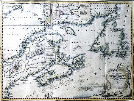
A New Chart of the/ Coat of/ NEW ENGLAND , NOVA SCOTIA / NEW FRANCE or CANADA,/ with the islands of NEWFOUNDLd CAPE BRETON/ST. JOHN’S&c./done from the original published in 1744/at Paris / by Monsu N.Bellin, /enginier [sic] to the marine office. This chart is most humbly/dedicated to the BritshMerchts/ trading to NORTH AMERICA/ by the editor
Four insets:
Atlantic Ocean[showing relative positions North America and Europe]
Plan of the City and Port of Louisbourg
Fort Dauphin
City of Quebec
Title cartouche and vignette of the attack on the fortress of Louisbourg and lighthouse. Attractive hand tinting by an early hand. Cut close. Matted glazed silver gilt-wood frame.
13 3/8 x 18 ½" (34 x 47 cm.) Frame: 19 x 24" Ref. SmacD1(194)/RNN/v.anad> GOL PRICE CODE C
Published in the Gentleman’s Magazine Feb 1746 This attractive copperplate map engraved by Thomas Jefferys after that of Jacques Nicholas Bellin (1703-1772) which was published in Paris 1744. Depicts the extent and glory of French colony of New France .The significant French port of Louisbourg is shown prior to its 1745 siege by New Englanders from the 13 colonies.
Home | Contact | Location | Links | Antique Prints | Fine Art | Antique Maps | Omnium Gatherum | Specialty Services