![]()
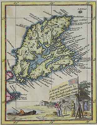
Kitchin - Cape Breton
MAP of ROYAL/ or CAPE BRETON I. / from the best authorities / By Tho: Kitchen Geog.
Thomas Kitchin London 1747
Original Copper engraving, printed on laid paper with full body colour, Title vignette.
Size 6 3/8 x 4 1/16" (16.2 x 10.3 cm) Ref. LRAdl273/av.rn/dn.dovo>RGL PRICE CODE B
Published in the London Magazine vol. 16, July 1747 p.305. This charming map has, within a border, a splendid title vignette occupying the lower third of the page. It depicts four figures, an Acadian stone farmhouse, a wheel barrow, title within a prominent Ensign flag, a small boat drawn up against the shore and a fishmonger selling cod to a new settler occupying the farm since the deportation of the French Acadian colonists of Isle Royale to France. The full body colour hand-tinted map shows St. Paul Is. as well as numerous Cape Breton place names lakes, rivers and topographical features. This is the earliest English separately printed map of the Island following the June 1745 bombardment and capitulation of Louisbourg to New England forces. It is also one of Kitchin’s earliest maps, just two years after he began his career. The Island was restored to France under the peace treaty of 1749 consequently this vignette, of a significant moment in Canadian maritime history, makes this decorative little map highly desirable for collectors.
Back
Home | Contact | Location | Links | Antique Prints | Fine Art | Antique Maps | Omnium Gatherum | Specialty Services