THE MAP THAT CAUSED THE CONTROVERSIAL FRENCH FISHING RIGHTS IN WESTERN NEWFOUNDLAND
MOLL. ATLANTIC PROVINCES
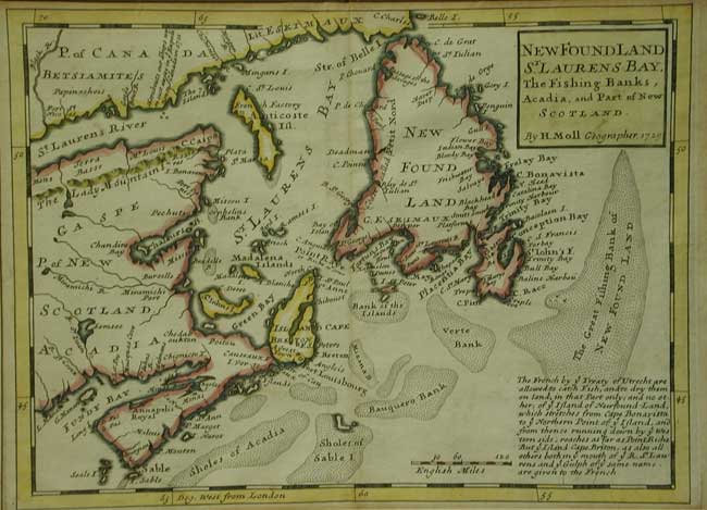
NEWFOUNDLAND/ St LAURENS BAY,/ the fishing banks, /Acadia, and part of New / Scotland
Hermann Moll, Geographer [London] 1729
FIRST STATE outline colour. Scale of English miles. Note on treaty of Utrecht.
7 ¾ x 10 ½” (19.9 x 26.8 cm.)
Published in Hermann Moll ‘ Atlas Minor: or a set of Sixty two New and correct maps of All Parts of the World,’ London 1729
Depicts The Atlantic provinces of Canada including part of Quebec, Newfoundland, the Maritimes and Sable island. Topographical features, along with political boundaries by colour and many towns are delineated. The north shore of the St Lawrence river is identified as being inhabited by Betsiamites and Lit. Eskimaux. In the vacinity of Pte des Monts, a note states that ships of a 1711 expedition to Canada were lost. There is an almost vertical delineation of Anticosti Island and the cod fishing banks are featured prominantly. A further note (Bottom Right) states that by the 1713 treaty “The French by ye Treaty of Utrecht are allowed to catch fish, and to dry them on land in that part only; and no other of ye island of Newfound-Land, which stretches from Cape Bonavista to yeNorthern point of ye island, and from thence running down by ye western side, reaches as far as Point Riche. But ye island of Cape Briton, as also all others in ye mouth of ye R. St Laurence and ye Gulph of ye same name, are given to the French.”
On the map, below Point Raye is engraved “or Riche as some” This probable mistake by Moll led to French interpretation of their being able to claim fishing and drying rights along most of the Western coast of Newfoundland under the treaty, from the 1730’s to 60’s.
Pointe Riche, the southern limit of the French Shore is located at 47°40' north latitude. In 1763 the French attempted to use this map to establish their claim to the west coast of Newfoundland, arguing that Point Riche and Cape Ray[e] were the same headland. Governor Hugh Palliser and Captain James Cook found evidence to refute Moll's claim and in 1764 the French accepted the placement of Pointe Riche near Port au Choix.
This significant map is a cornerstone of any collection of foundation maps of Canada.
Herman Moll 1654 - 1732 (fl.1678-1732) A bookseller, geographer and engraver of German, or possibly Dutch, origin. He flourished at the end of the great Dutch period of cartography and the rise of the British era, during the reign of Queen Anne. Around 1678, he moved to London. Where for a while he continued as an engraver for Moses Pitt, Greenville Collins, John Adair and Seller & Price. In 1688/9 he started his own business from his own shop, as a map publisher and map seller in Vanley's Court, Blackfriars, but later settled in Devereux Court, Strand. By the turn of the century had become the most prominent map publisher in the country. Although the distinctively and characteristically Moll maps came later (during Queen Anne's reign, 1702-14), his individual style of mapmaking becoming increasingly more distinct as his career progressed.
His work had a high reputation and was much copied by other publishers. He published atlases and loose maps of all parts of the world many of which were highly decorative, as well as geography books. In 1729 he published his Atlas Minor ... changing the delineation of Acadia to a more realistic shape from his earlier format, which had been based on Thornton’s maps.
Moll had a gift for making interesting friends, and these included Daniel Defoe, Jonathan Swift (he provided maps for Robinson Crusoe and for Gulliver's Travels), explorer/buccaneers William Dampier and Woodes Rogers, the scientist Robert Hooke, and the chemist Robert Boyle He died in St.Clement Danes in 1732.
“Herman Moll, was one of the most significant and distinctive European cartographers of the late seventeenth and early eighteenth centuries. He enjoyed a lengthy and productive career that spanned almost six decades and yielded more than two dozen geographies, atlases, and histories, as well as myriad separate maps, charts and globes spanning the known world. Although generally not held in high regard for the originality or content of his cartography, he possessed a strong and tasteful design sense that, when combined with his engraving talents, led to the creation of unique and aesthetically pleasing maps, some of which must be considered graphic masterpieces. Moll and his maps also flourished during the fascinating and dynamic era of the British Enlightenment and the early, heady days of empire.
Although he spent most of his working life in London, Moll probably was born in the once-great German Hanseatic city-state of Bremen in 1654 and likely came to London in the mid-1670s as a refugee from the turmoil of the Scanian Wars, during which Bremen was overrun. Moll probably learned his engraving skills in his native Bremen or elsewhere on the Continent before coming to England. He was part of an already well established North German movement to England and especially London that climaxed with the accession of King George I and the House of Hanover in 1714.” Dennis Reinhartz The Cartographer and the Literari: "Herman Moll and His Intellectual Circle"
References: Kershaw K.A. Early Printed maps of Canada Vol. II #571 Phillips LD. A list of Geographical Atlases in the Library of Congress #574-57
Home | Contact | Location | Links | Antique Prints | Fine Art | Antique Maps | Omnium Gatherum | Specialty Services
