

D’Anville, Pownall - Americas.
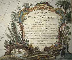
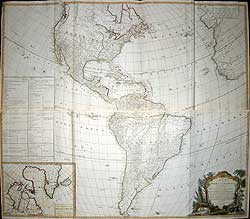
A NEW MAP/ OF THE /WHOLE CONTINENT/OF AMERICA, divided into/North and South and West Indies. wherein are exactly described/the United States of North America/as well as The Several European Possessions/ according to the preliminaries of peace signed at Versailles Jan 20. 1783,/ Compiled from Mr. d’Anville’s maps of that continent,/ with the addition of the Spanish Discoveries in 1775 to the North of California/& corrected in the several parts belonging to Great Britain,/ from the original materials of Governor Pownall. MP./ London. Published by Laurie & Whittle 1794.
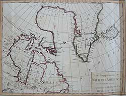
Inset: The Supplement to/ North America/ containing the countries/ adjoining to Baffins &/Hudson’s Bays.
Large Copper engraved map on four sheets (in two sections). Printed on wove paper. Original outline hand colouring. Elaborate title cartouche with alligator and native plumage. Six scale bars, two informational boxes. In excellent condition. 40 ¾ x 46 ¾” (103.50 x 118.74 cm.) when joined.
Ref. LRA906m/ADL/v.dosa> RRLN PRICE CODE H
A variant of the map by John Gibson Engraved by Thomas Kitchen, and others originally published by Robt. Sayer, Map, Chart & Printseller, 1786. in ‘A General Atlas, describing the whole universe’.
The outline of the Great Lakes is delineated after D’Anville. The United States is now titled as such. Although West Florida was claimed by the United States as part of the Louisiana Purchase, it is still shown as Spanish territory on the map. The post-Revolutionary War border between the United States and Canada, as determined at the Treaty of Paris of 1783, is engraved on the map and outlined in red, as are other British colonial territories. The table at left lists the various territories and islands in the possession of the United States, Great Britain, Spain, France, Portugal, Denmark, and the Netherlands.
The Northwest coast is relatively well mapped, as a result of the use of Spanish & British sources. Showing the discoveries of Cook, Dixon (Queen Charlotte Is) & Vancouver & Quadra's Is. The beginnings of the mapping of the ‘Rocky Mountains of Bright Stones’ and the coastal ranges in Canada and the Northwest are in evidence. The Pacific coastline is divided into New Albion, Nw Georgia, Nw Hanover. The erroneous ‘New Sea’ in Labrador is also depicted as is ‘Land seen in 1787’ in the Davis Strait, which is probably the tip of the Cumberland peninsula. The names and locations of Indian tribes are given throughout both North and South America. The inset map at lower left is of N. E. Canada, focusing on Hudson's and Baffin's bays and conjoined Greenland.
Jean Baptiste Bourguignon D’Anville (1697-1782) was one of the most important and prolific cartographers of the 18th century and his influence on his contemporaries was profound. He was foremost in using the latest and most accurate cartographic information available, incorporating the latest discoveries of the many French, British & Spanish explorers.
He engraved his first map at the age of fifteen and produced many maps of high quality throughout his career. He became the finest cartographer of his time and carried on the French school of cartography developed by the Sanson and the de L'Isle families. He was appointed Royal Geographer and Cartographer to the King of France in the middle of the eighteenth century,
Governor Thomas Pownall (1722-1805) was the influential British MP. and former Governor of New Jersey & later Massachusetts who had particular influence with regard to British Colonial affairs in America.
Laurie and Whittle (fl. 1794 - 1858) was a London, based firm active in the late 18th and early 19th century. Generally considered to be the successors of the Robert Sayer firm, Laurie and Whittle was founded by Robert Laurie (c. 1755 - 1836) and James Whittle (1757-1818). Robert Laurie was a skilled mezzotint engraver and is known to have worked with Robert Sayer on numerous projects. James Whittle was a well-known London socialite and print seller who's Fleet Street shop was a popular haunt for intellectual luminaries. The partnership began taking over the general management of Sayer's firm around 1787, however, did not alter the Sayer imprint until after Sayer's death in 1794. Together Laurie and Whittle published numerous maps and atlases, often bringing in other important cartographers of the day, including Kitchin, Faden, Jefferys and others to update and modify their existing Sayer plates. Robert Laurie retired in 1812, leaving the day to day management of the firm to his son, Richard Holmes Laurie (1777 - 1858). Under R. H. Laurie and James Whittle, the firm renamed itself Whittle and Laurie. Whittle himself died in six years later in 1818, and thereafter the firm continued under the imprint of R. H. Laurie. After R. H. Laurie's death, the firm and the printing stock came under control of. A. G. Findlay (1873), who had long been connected to the Laurie and Whittle firm and D.& W. Kettle (1875). Part of the firm still exists today as Imray, Laurie, Norie and Wilson Ltd., an English publisher of maritime charts.
Vide. Tooley R.V. The Mapping of America, p. 52, 3 1794 f. Holland Press London 1980
Home | Contact | Location | Links | Antique Prints | Fine Art | Antique Maps | Omnium Gatherum | Specialty Services
