![]()
ONE OF THE MOST ATTRACTIVE WORLD MAPS OF ITS ERA
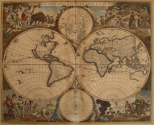
Frederick De Wit Double Hemisphere Map of the World
NOVA ORBIS TABULA IN LUCEM EDITA A. F. De WIT.
Second State, De Wit, Amsterdam [Ca. 1670] Original hand coloured copper engraved map. Decorative corner vignettes, decorative border. Laid to card. Matted.
18 13/16 x 221/2" (47.9 x 57.2 cm) PRICE CODE I Ref. LRA1289 /ANN/ l.andr > LONN
A rich and beautiful early hand tinted example of De Wit's striking double hemisphere map of the world which is "considered to be one of the most attractive maps of its time. " [Shirley p. 469]
The map was first published ca. 1670 in atlases by de Wit and is here we offer it in its second state, ca 1680; The cusps now being filled with cherubs and an outer border added.But it is the brilliant allegorical scenes in the corners which combine images of the four seasons, the elements and the signs of the zodiac in a well-balanced and natural way that make this map such a desirable collectors prize. Shirley remarks that while this map is often described as circa 1680, it was likely engraved in the late 1660s, based upon the Great Lakes and somewhat curious Hudson Bay cartography. There is also significant new cartographic detail in Southeast Asia and to the north of New Zealand based on the discoveries of Tasman from both his voyages in 1642-43 & 1644. Terra Australis Incognita is not charted. The map shows the Briggs model of California as an island, with a flat top and the Straits of Anian. The map was later republished after 1689 with certain revisions such as the adding of a privilege secured by De Wit in 1689, and the new presence of Nova Guinea on the western sphere. De Wit also illustrates two smaller hemispherical representations of the Arctic and Antarctic poles.
The original early hand tinting is rich. Prior to WWII the map was laid down to card to strengthen weakness along the original centerfold and small hole lower right.
The map has lain untouched and in darkness since 1945 until its re discovery in 2013.
Shirley, Rodney W. The Mapping of the World: Early Printed World Maps 1472-1700 #451 (state 2 of 2)
Koeman I.C. Atlantes Neerlandici, v. 3, Entry Wit 1
Home | Contact | Location | Links | Antique Prints | Fine Art | Antique Maps | Omnium Gatherum | Specialty Services