![]()
 |
 |
POWNALL BOWEN/GIBSON-NORTH AMERICA
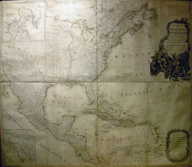
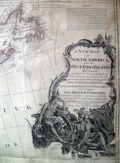
A NEW MAP OF NORTH AMERICA with the WEST INDIA ISLANDS...THE UNITED STATES and the SEVERAL PROVINCES, GOVERNMENTS &ca. which compose THE BRITISH DOMINIONS... of Goverr. Pownall, memre. of Parliamt.
Inset: 1. A Particular map of Baffin and Hudson's Bay
2. The passage by land to California.... Island
Attributed to Kitchin, Thomas; Pownall, Thomas; [Emanuel Bowen and John Gibson] Published by Laurie & Whittle, London 1794
Copper engraved map Four sheets mounted as one. Slight discolouration, original colour, decorative cartouches.
39 3/4 x 45 3/4" (101 x 106 cm) Ref: BD2 /LLNN/ g.anno > VOLN PRICE CODE J Click here for price guide
A splendid large scale (1:5,300,000) map of North America and the West Indies descended from the Gibson /Bowen 1755 parent map, and printed on four conjoined sheets. incorporating the latest political and geographical information. Like its predecessor was consulted during the settlement of numerous boundary disputes. Depicts the vastness of North America from James Bay to the Spanish Main, showing considerable internal detail.
Shows the theatre of North American conflict during the French and Indian/ War Seven Years War 1756-63 and the subsequent events of the American Revolution leading to the Peace of Paris and Versailles 1783. A rare snapshot of North America at the beginning of its age of internal exploration.
Territorial boundaries are delineated according to the Treaty of Paris and Versailles 1783 with Article III of the treaty appearing in the top right hand corner of the upper right sheet. A most desirable map for collectors.
Vide: Tooley Mapping of America, p.83, 49(K)
Clements, vol I, p.384
A really clear scrollable view of the 1786 edition may be seen by clicking this link
Home | Contact | Location | Links | Antique Prints | Fine Art | Antique Maps | Omnium Gatherum | Specialty Services