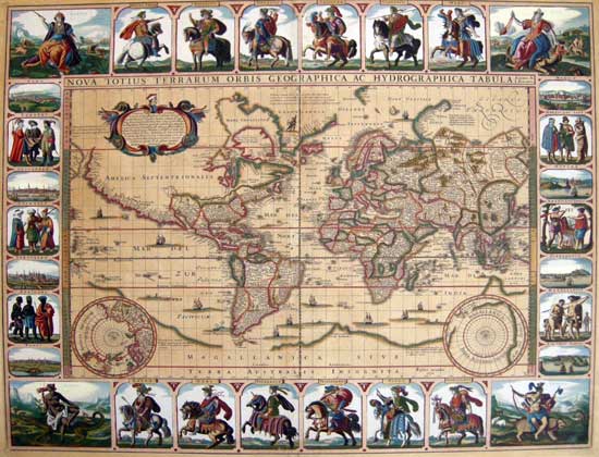
A RICHLY EMBELLISHED AND EXTREMELY RARE WORLD MAP BY A SEMINAL DUTCH MAPMAKER
Claes Janszoon Visscher
Nova Totius Terrarum Orbis Geographica ac Hydrographica tabula Autore N. I. Piscator
Amsterdam 1639 (1652)
RARE. Copper engraved map, Original hand colouring. Trimmed to neat line, with margins extended and laid down to backing.
17 13/16 x 22 3/16 " (45.3 x 56.4 cm)
Ref. LRA 1290/ ANN/ g.andr >ANLNN PRICE CODE L Click here for price range guide
Known as the 'twelve Cæsars' map. This magnificent scarce example has remained untouched and out of the light since prior to WWII
It is the original rich saturated hand tinting by an early hand,that makes this map an impressive and highly desirable addition to any collection.
As was the fashion among the learned elite of the time, Visscher often used the Latin version of his name, signing his works "N. I. Piscator" ("Piscator" meaning fisherman), as on this superb world map of 1639 (shown here in the state of 1652). The detail in the map is quite remarkable. The map was updated geographically to show discoveries around Hudson's Bay, and a longer St. Lawrence River extends to a small lake in the middle of North America.The Straits of Le Maire and Magellan are shown, and the massive Magellanica Sive Terra Australis Incognita. Beach is still shown in the region that would become Australia, based upon the reports of Marco Polo. The early Dutch discoveries in what would become northern Australia are shown. A somewhat fictional California coastline appears (but with the Baja shown correctly as a peninsula), heading north toward the Straits of Anian.....
But it is the magnificently embellished border which is a prime example of Visscher's acclaimed artistic inventiveness, and includes twelve Roman emperors mounted on richly caparisoned horses, - thus often called the "Twelve Cæsars Map".
Vide: Shirley, Rodney W. The Mapping of the World: Early Printed World Maps 1472-1700 #350
Please contact us for full description.
Home | Contact | Location | Links | Antique Prints | Fine Art | Antique Maps | Omnium Gatherum | Specialty Services
