Since 1763 the name 'Russborough' has been synonymous with collecting and dealing in fine art. In the closing decades of the last century the historic town of Port Hope has become home to Lord Russborough's Annex, which specialises in an individual mix of antique maps, paintings and prints.

While Lord Russborough's Annex features a great many works of museum calibre, we also offer a wonderful selection of prints priced at under $100.

The Red River Settlement - a brief history

Through the eyes of the white man, the Great Plains of North America at the beginning of the 19th century, were a Great Lone Land. Where upon millions of buffalo ranged freely between the Great Lakes and the Rockies, and the land north and south between the Saskatchewan and the Colorado rivers… a no-man’s land, rich for the taking, populated sporadically by groups of semi-nomadic Indians of no particular consequence. The latter understandably had a different take.

In what is now Canada, the vast territory of western Canada was under the control of the rival Hudson’s Bay Company (H.B.C.) and North West Company (N.W.C.), whose principal occupations were the profits to be derived from fur-bearing animals.

Trading centered around various forts or posts, which they built or acquired, following the fall of New France. (See Map #1)

The Siouan and Algonkian (Algonquian) - speaking Indians, coexisted with the Métis, (French-Canadian half-breeds being descendants of French and English voyageurs who had settled among the indigenous communities). The latter were found to be quite useful as a source of purveyors of food; particularly Pemmican, a highly nutritious by-product of the buffalo hunt, which centered on the Red River.

In 1811, Thomas Douglas 5th. Earl of Selkirk financed an agricultural alternative to the buffalo hunt. His grant of land became known as the Selkirk or Red River Settlement. The conflicting interests of settlers and fur traders caused not only the tide of ill-feeling between the two trading companies to pour forth, but also caused considerable unrest amongst the Métis and half breeds, which resulted in the Pemmican War of 1816 and the atrocities at Seven Oaks.

Following the arduous struggles of the early years of the Selkirk settlement, especially in the year of the flood (1826) and plagues of grasshoppers and mice, the 1830s were years of ‘peace and plenty’. The H.B.C. and N.W.C. having been united in 1821 (10 March), and the various ethnic groups within the settlement lived in relative peaceful coexistence. The Métis prime occupation was still the buffalo hunt, along with providing service and transportation facilities to the fur traders of the H.B.C. Most of their work was seasonal however, resulting in a ‘feast or famine’ existence. By nature, they willingly gave in times of feast but found it difficult to come to terms with the lack of reciprocal charity from the H.B.C. in times of famine.

With Selkirk’s death in 1820, the creation of the H.B.C. controlled District of Assiniboia in 1835 (being the land within a 50-mile radius of Fort Gary) was a particular cause of resentment. In Métis eyes, it was created to “whet the apparent greed of the H.B.C. in their efforts to prevent the Métis acting as free fur traders themselves” by rendering legally inaccessible the profitable trading post which American’s had set up at Pembina, for example. Furthermore, the Métis were regarded as squatters by the H.B.C. on land that the former regarded as ancestrally theirs, regardless of formal title. The Métis and half breeds petitioned the District Council for representation and acknowledgment of their special status. Their petitions were ignored. So were planted the seeds from which rebellion grew.

In 1845 U.S. expansionism posed a real threat of annexation which prompted the H.B.C. to request British troops. 346 men left Cork, in then famine blighted Ireland, on 26 June 1846 to combat strife in the New World. As the Oregon crisis receded, and the US. Canada border established, so did the need for troops and they were replaced in 1848 by 56 Chelsea pensioners. (See item 1.)

The skillful political brinkmanship of Jean-Louis Riel in 1849 resulted in the sensible solution of concession and acknowledgment of the aspirations of the Métis people and the breaking of the H.B.C. fur trade monopoly, thus bringing 20 years of tranquility to Assiniboia. During this time, it became evident that the days of company rule in British North America were numbered.

By 1858 with the arrival of the railway at St. Paul (Min.) and the following year, the appearance of the first steamboat on the Red River, the inexorable fingers of communication reached out from the east, limiting the isolation and insularity of the colony.

The dictates of men’s fashions in the 1860’s saw the end of the beaver fur trade (just as today’s fashion shifts spelt the end of the Newfoundland seal skin trade).  Meanwhile, the idea of Canadian expansionism was gaining momentum fuelled by the reports of Palliser, Hind and others. (See item 2) Further concern over U.S. expansionism following the American Civil War, spurred Britain to tighten its hold over its possessions westward of the Canadas. As early as 1857, negotiations had begun with the H.B.C. to bring Rupert’s Land into the Dominion. With the passing of the British North America Act, negotiations began in earnest, resulting in the 1869 Canadian Act which created a temporary government of Rupert’s land.

The relationship between the settlers, Métis and first nations Indians were initially relatively harmonious, each interacting and learning from the others culture, without major crime. Eventually pressure on the dwindling resources of the approximately 30 settler family community caused dissent, especially upon the arrival of over 600 Sioux. Then, for three years in the late sixties came the devastating plague of locusts and the failure of the Buffalo hunts. Starvation was rampant. The settlers wired for international help, which raised over £7,000 in relief aid.

The Canadian government of the day again chose to ignore the Métis land claims to their cost, for this time, the Métis had had enough, and in their midst, was an eloquent champion for their cause.

Red river 1 Tallis Brit Amer RY24

1. TALLIS – BRITISH AMERICA.
J. Rapkin,  J.& F. Tallis

Vignette of Hudson City, Seal, Whale Fishery, Polar bear, Fury & Hecla, Esquimaux
 J. Rapkin. London [1849-1851] Published by John Tallis. London, Edinburgh, Dublin 1849
RARE. Hand tinted steel engraved map, decorative vignettes, Scale bar, Matted, Glazed, gilt wood frame.
Map: 10 3/8 x 12 7/8 (26.3 x 32.7 cm.) Frame 18 x 22"
Ref. RY24 (179)/ DLN /r.ando>GGN    PRICE CODE C

This is one of the most popular Canadian maps for collectors as it shows, in considerable detail the British possessions in North America. This particular version is a rare and curious second state, first edition of Tallis’s 1849 map of British America or what is today Canada. 
The map is based on later editions of J. Arrowsmith's Map of British possessions in North America most of which was to become Canada.   Delineated in outline colour and named are the various administrative and settlement districts (including Red River), fur trading districts and posts of the amalgamated Hudson Bay Company, (but not Fort Garry on the Assiniboin, although Fort Pitt Saskatchewan district is). At the time, the fur trade was the principal economic source of Northern Canada. Principal towns, mountain ranges, rivers and lakes are also located. Indigenous tribal areas are also shown. In Southern Ontario (Canada West) the village of Colbourn (1840) is shown.  In the Arctic, Committee Bay (1846/7) is located, as are the Parry islands, discovered in 1823, during the then ongoing search for a North-West passage. The Map extends from Russian America (Alaska) east as far as Greenland and Iceland. 

The border now corrected along the 49th parallel following the Oregon Treaty 1846, but part of the territory is still named 'New Georgia'. Inexplicably the vignette of Boston is here named Hudson City. Six attractive vignettes characterize this Tallis map: Hudson City; Seal; Whale fishery; Polar bear; Parry's exploring ships 'Fury' & 'Hecla' and Esquimaux. Later versions of this map would replace the Boston view with one of Montreal. 

Tallis Brit America Hudson city

John Tallis and Company published views, maps and atlases in London from roughly 1838 to 1851. The principal works, expanding upon the earlier works of Cary and Arrowsmith, include an 1838 collection of London Street Views and the 1849 The British Colonies; Their History, Extent, Condition and Resources. Edited by R. Montgomery Martin and the Illustrated Atlas of the World London 1851, which was issued to coincide with the Great Exhibition in London 1851. His principal engraver was John Rapkin (ƒl.1845 – 1851), whose name and decorative vignettes appear on most Tallis & Co. maps. Due to the decorative style of Rapkin's work, many regard Tallis maps as the last bastion of English decorative cartography in the 19th century.
The London Printing and publishing Company of London and New York bought the rights for many Tallis maps in 1850 and continued publishing his Illustrated Atlas of the World until the mid 1850s.
The Bristol Times
observed that Mr. Tallis maps "are not only critically correct, but are accompanied with elegant and appropriate engravings illustrative of the manners and costumes of the different countries."

  Red River 2 Kakabika

 2. THE CANADIAN RED RIVER EXPLORING EXPEDITION
Kakabika [sic] or Grand Falls, Kaminitiqua [sic] River, Lake Superior/ Ford of the Roseau River, and Indian Fish-weir.

SCARCE.  Pair of wood engravings plus text on verso.  Published in the Illustrated  London News 2.10.1858                                      9 ½ x 13 ½” (24 x 34 cm.)
Ref. RR2.Cat 7 #6 LRA WC7 /DD.LN/e.dnsl > ADN          PRICE CODE  B

 
Two scarce and, according to the extensive text on the reverse, the first published views of the expedition taken from the originals accompanying Hind’s report. These views were published by arrangement with Hind and the Governor General. The 119’6” high Kakabeka Falls were surveyed by Dawson in 1857. The Roseau Ford is the place where the trail from the Red River Settlement crosses the river enroute to St. Paul, Minnesota. Skeletons of Indian wigwams and a sweating house are seen on the bank along with a fish-weir in the river. The three intrepid explorers on horseback in the foreground. There is a lengthy, very interesting, description of the expedition in the text on verso.

It took some 33 days to traverse, through difficult terrain, the country from Fort William to Fort Garry. Dawson’s new route, The Dawson Road an all Canadian route which reduced the distance from the Lake of the Woods to the Red River. Hind described the Red River valley “as possessing a remarkably deep rich and fertile soil.” Over a million acres in which “all kinds of vegetables commonly cultivated in Canada succeed and the root crops acquire surprising dimensions”. He reported “The state of society was not encouraging however, with European and Canadian elements diminishing, and the half-breed population is apparently drawing closer to the habits and tastes of their Indian ancestry”.

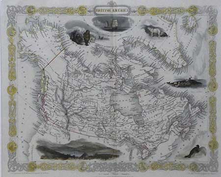
The Creation of Manitoba 1869

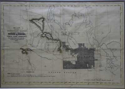
The uncertainty of the Canadian government’s plans concerning Assiniboia, and the hardships caused by the 1868 plague of grasshoppers, caused the seeds of rebellion to flourish in spite of the fact that both Canadian and international relief was raised to diminish the distress. Using the pretext of survey for a proposed wagon road (see item 2)  to assist in transporting relief aid, a further survey of the Red River Territory was instituted.  The Métis were exacerbated by the rumored threat of annexation of Assiniboia by the United States via the Fenians. For the Métis, uncertain of their land tenure rights, this was too much. On October 11, 1869 Louis Riel brought the survey to a halt. With his foot on the surveyor’s chain, he and his 18 followers calmly informed the surveyors that “the Canadian Government has no right to make surveys in the Territory without the express permission of the people of the settlement”. The majority of the original white settlers agreed with him.

His timing was perfect, for the transfer of the H.B.C.’s Rupert’s Land to the Dominion had not being completed due to a certain lack of funds on behalf of the Government of Canada, so there was a general uncertainty as to who had jurisdiction. Moreover, there was still great difficulty in communicating with the settlement swiftly and this was complicated by the fact that neither London nor Ottawa claimed to have (nor indeed apparently cared to have) accurate knowledge of the local situation with regard to Métis land claims, in spite of the advice and warnings concerning the situation given to Ottawa.

Riel and his supporters formed ‘La Comité National des Métis de la Rivière Rouge’ which confronted William McDougall, the Governor-Designate, at Pembina, and forbade him entry to the settlement. Riel, realizing the strategic importance of Fort Garry, proceeded to occupy it on November 3. Whereupon, he set up a Provisional Government and issued his proclamation of 8th December,1869. Thus was Manitoba born.

Prime minister Sir John A. Macdonald reacted with uncustomary swiftness to contain the situation, by halting the transfer deal with the H.B.C., advising MacDougall to wait in Pembina for further instructions, and dispatching Bishop Taché to the Red River. He also dispatched as his emissary Donald A. Smith (later Lord Strathcona) with orders to placate and reassure the Métis that they would have representation within the new Dominion. Smith arrived at Fort Garry on the day of Riel’s proclamation.

Dateline: Manitoba 1870 -The Unrest Foments. 

The first two months of the year at (upper) Fort Garry were taken up with the discussions of the Convention held to establish a provisional government for Manitoba, agreement being reached in the early hours of February 10/11. The volatile Reil was becoming increasingly erratic. It was during this period that some of Riel’s inhumanly treated prisoners escaped from the Fort, to try and raise an insurrection against Riel. One of them being W. J. Allen, a Sergeant in the Durham Light infantry from Port Hope. [Having made his escape, he was much fêted upon his return to Port Hope.] Another amongst them was the belligerent Orangeman,  surveyor Thomas Scott. He was later recaptured and ordered by Riel, with whom he had a personal vendetta, to be shot on March 4 for his participation in the insurrection - an act which was to dog Riel for the rest of his life.

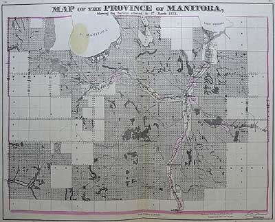
Feelings of revenge in the Orange order of Ontario against, and in Québec sympathies for, the new Province ran high, and were the cause for considerable concern to both MacDonald and Cartier, back in Ottawa. They strongly influenced the tone of the reception given the three Convention delegates to Ottawa. However, the outcome of negotiations resulted in the Manitoba Act of May 12, which limited the size of the new Province and acknowledged the rights of the Métis.

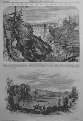
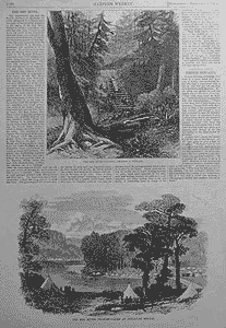
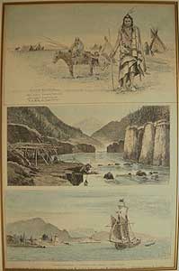
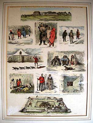
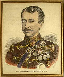
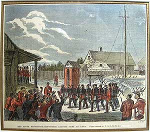
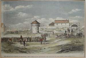
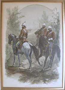
 Meanwhile, a volunteer expeditionary force about 1,000 Canadian military under Colonel (later Field Marshal and Viscount) Garnet J. Wolseley (see item 6) arrived at Winnipeg on August 24th. after an arduous overland 1,500 mile trek via the Dawson Road, (see item 3) to find that Riel had departed for the United States.  Eager for vengeance, the troops caused considerable bloodshed and such ill feeling (see item 5) among the Métis and settlers in the nine days prior to the arrival of the first Lieutenant Governor of the Province, Adams G. Archibald, an able and just man, that many Métis removed to the North West Territory (see item 10). There they nursed their discontent for another 15 years, whilst cherishing their traditional way of life. The Red River Rebellion was over, while the seeds of yet another lay dormant.

"I have never been associated with a better set of men"    Col. Wolseley

RR3 Matawan

3. THE RED RIVER COUNTRY- CROSSING A PORTAGE/CAMP AT MATAWAN BRIDGE

SCARCE.  Pair of wood engravings plus text.  Published in  Harper's Weekly December 2 1871      15 ¼ x 10 ¾” (38.7 x 27.3 cm.)  
Ref. Cat 7 #33 LRA WC9 /DD.LN/r.dnsl>DGN   PRICE CODE B

The surrounding text vividly describes, if albeit somewhat over simplified, the incredibly hard conditions and health encountered by Wolseley’s expeditionary force enroute to the Red River settlement for the suppression of the Red River Rebellion. This makes for a contemporary interesting read from Capt. G. L. Huyshe's account, also listed are the daily rations for the men. The two views show the camp of Wolseley's expeditionary force at Matawan Bridge with the bell tents pitched among the trees. Also, dramatically depicted is the difficulty encountered in portaging the heavy wooden boats La Belle Manitoba & The Flying Dutchman.

RR4 Tableaux

4. EXPOSITION DES TABLEAUX ET DESSINS DU CANADA
par Gaston Roullet par Georges Petit.
3 views: Chef de Peaux-Rouges; Pècheries de Peaux- Rouges; Lac Supérieur

 Hand tinted wood engraved lithographs, double-matted, glazed, natural wood
 13 1/4 x 8 1/4" (33.7 x 21 cm.) Frame 19 ¾ x 14 ½" 
Ref.  AH16(144) /GN/ g.andg> AEN     PRICE CODE B

Published in L’Opinion Publique 1870? An interesting contrast is captured in these views between indigenous natives living at-one-with-nature and white settler’s technological advances to tame it.   Two images depict a Blackfoot Indian encampment; Indians catching fish from a stage built out over a river and a fish drying scaffold; and a third illustrative of life off the shore of Lake Superior with a lighthouse, steamboat and fishing vessel.  

RR5 Reminiisences

5.  REMINISCENCES OF THE RED RIVER EXPEDITION, BY A VOLUNTEER OF THE ONTARIO BATTALION
Fort Garry
Squaws and Papooses
The Sentinel's evening visitors
 Indian loafers
An Indian dog team
Dusky Loungers'
 Indian " Dolce far Niente"
 An aboriginal gentleman occasionally present at guard mounting
 Casting sheep's eyes through the port-hole
Little Fort Garry
Scarce. Canadian Illustrated News. 2.9. 1871. matted, glazed, black & gilt-wood frame 21 x 16"
Compilation of ten hand tinted wood engraved images on one page.
14 x 10" (35.5 x 25.4 cm.) Frame 21 x 16"
 Ref.AL6(144)/GL/ g.andg> AVN    PRICE CODE B

This compilation gives an insight into life in and around Fort Garry in the Red River Settlement, views of both forts are shown.  The remaining eight images however are rather disparaging in their portrayal of the local Métis and Indians during the occupation of the expeditionary force. Meanwhile, the white settlers celebrated with a sigh of relief.  As with Lower Canada, the province of Manitoba  was introduced into Confederation  with many of the same cultural disparities.

RR6Wolseley

6. GEN. SIR GARNET J. WOLSELEY

Canadian Illustrated News 1874. 03.21.  Hand tinted, Wood engraving, double-matted, glazed, gilt wood frame.
Image 5 ¼ x 4 ¼" (13.3 x 10.8 cm.) Frame 13 ½ x 9 1/4"
Ref. AH22 (144) /LN/g.andg>ADN   PRICE CODE B

 A portrait of then newly promoted General Sir Garnet Joseph Wolseley (1833-1913) (later Field Marshal and created Viscount Wolseley) who led the expeditionary force to the Red River Settlement. He was much decorated as he rose through the ranks to become deputy quartermaster-general, at 34. The Red River expedition was a fine example of planning in which attention to detail enabled troops carrying all their own supplies to overcome some 600 miles of inhospitable terrain between Lake Superior and the prairies.  Lord Wolseley was among the foremost of the Victorian generals. Forced by lack of family wealth to make his own way, he was also driven by ambition to reach the highest levels in his profession. He was nominated GCB. for his work in Africa and was instantly recognizable as “the very model of a modern Major-General” when The Pirates of Penzance opened in London. In 1882, he was appointed adjutant-general. Winnipeg's district of Wolseley is named for him and the Glenbow Museum holds some of his interesting memorabilia.

RR7Engineerslevis
7. RED RIVER EXPEDITION- Engineers leaving camp Levis
from a sketch by W.O.C. Lt. RA.
Canadian Illustrated News 1870.06.04.  Hand tinted, Wood engraving,  matted, glazed, natural wood frame.   Image 7 ¾ x 9" (19.7 x 22.9 cm.) 13 ¾ x 14 ¾"
Ref. AH14(144) /EN/g.andg> AEN    PRICE CODE B

William Ogle Carlisle (fl. 1870-76) was a lieutenant in the Royal Artillery. He sketched this image of a detachment of engineers departing Camp Levis for the long route march (being the best part of 2000 miles.) to the Red River settlement, much of it through inhospitable country. Wolseley's organizational skills made much use of their talent by his out-of-the-box deployment of them along the rudimentary Dawson Road.

Events: Manitoba 1871-1884 growth, legislation and tension


During the first year after the new province was created the legislature was organized, a population census was taken and the land survey continued (see item 10 & 11). Treaties #1and #2 were signed with the Indians whereupon the Dominion Land Office was established, for with the Métis and native titles cleared, land grants could now be made.

In the fall of 1871 much excitement was created by the Fenian raid, (see items 8 & 9) organized by the Irish extremist, W.B.O’Donoghue, which Riel helped suppress, once again bringing up the question of amnesty for the insurrection and Scott trial. It became a major political issue that was to drag on for years, with the government in Ottawa trying to wriggle out of its verbal promise of an amnesty, for the political expediency of placating Ontario.

Meanwhile Winnipeg was growing rapidly as it took on a new importance as a center of supply to both east and west. In 1870 there were less than 300 residents in the town's 30 odd buildings. By 1875 the population had risen to 5,000 and over 1,000 buildings: the 'Wild West' atmosphere was yeilding to the 'New Chicago' image.

Immigration to the province tripled with new towns and farming communities appearing. Escaping the persecution of Czar Alexander II, the Mennonites arrived in 1873-4 in the Steinbach area and set new standards in open prairie farming. The 1873 eruption of the Iceland’s Hecla volcano prompted the removal in 1875 of 285 Icelanders to the Gimli area.The great lone land of North West Canada was indeed now open for pioneering settlement. (see item 14)

In 1873 Riel was twice elected as Federal M.P. for Provencher.  Upon trying to take his seat the following year, however, he was expelled from the House of Commons due to the political maneuvering of the Orange faction amongst the Ontario members. With a price on his head, he was forced to flee, eventually settling in Montana. 1873 was also the year the Northwest Mounted Police (N.W.M.P.) (see item 13) came into being. After training in Winnipeg they commenced their ‘great march’ in 1874.

RR8 Cooks Corners

8. BIVOUAC DE VOLONTAIRES A COOK'S CORNERS
 1 view L'Opinion Publique 16 June 1870
Wood engraving laid to card. 6 ½ x 9” (17 x 23cm.)
Ref. Cat 7 #11a LRA -/-/r.dnsl>GN    PRICE CODE A

The military encampment of the 52nd Battalion at Cook’s Corners along the Eccles Hill frontier border, during the suppression of the Fenian Raid. After a sketch by Adolph Vogh.

RR9 Fenian excitemant
9. THE FENIAN EXCITEMENT IN MANITOBA-
The Commandant addressing the recruits at Fort Garry, From sketches by E.G.
  Canadian Illustrated News 1871.11. 04.  Hand tinted wood engraving, matted, glazed, gilt-wood frame.
 Image 6 ½ x 9 3/8" (16.5 x 23.8 cm.) Frame 13 ¾ x 15" 
AH13(144) /GL/g.andg> AEN     PRICE CODE B

W. S. O'Donoghue, the Fenian Irish extremist, in a foolhardy and vain attempt tried to enlist the support of discontented Métis and half breeds against Britain. Thereby striking a blow for Ireland's independence by annexing Manitoba to the U.S. and thus putting pressure on Britain. He gained support from the U.S. Fenian Brotherhood and crossed the Border at Pembina on 5 Dec. 1871 whereupon he took possession of the H.B.C. trading post. Riel, seeing an opportunity to demonstrate his British loyalty and help clear his name (of the Scott shooting), rebuffed O'Donoghue's overtures and instead raised a force of 400 hundred men which he offered to the Lt. Governor to help crush the raid. This force together with Wolseley's detachment and the US. cavalry easily dispersed the Fenians, so earning the gratitude of Lt. Governor Archibald. Unfortunately, this event did not bring forth the anticipated amnesty for Riel, for he had underestimated the power for revenge of the Ontario Orangemen.The image depicts Fort Garry, in front of which stand a number of the 400. 

RR10 map-man

10. DEPARTMENT OF THE INTERIOR - MANITOBA
Map shewing the Dominion Lands surveyed or explored in the Province of Manitoba and North West Territory also lands that it is desirable to survey in the season of 1873.

 [Department of the Interior, Ottawa 1892] [Topographical survey's branch] Hand-tinted lithographic map, tinted border 12 1/2 x 18 1/2 "(31 x 47 cm.) Frame 20 x 26"
Ref. #46 LRA /-/r.dnsl >LOL   PRICE CODE C

A hand tinted lithographic map issued to show the results of the surveys of the Dominion lands as a result of the signing of Treaties #1and #2 with the Indians. This early map of the area eventually formed part of the first official map of the new province of Manitoba. Originally commenced in 1869, the survey under Lt. Col. J.S. Dennis was brought to a halt by Riel's stance at St. Vital on October 11th. [see The creation of Manitoba 1869 text]. Recommenced however in 1871, this time respecting the Quebec style narrow river lot where it existed.

Published in the Topographical Survey's Branch, report of Operations, 1869-1889 by W. F. King and J. S. Dennis Feb. 1892. The map shows both the townships surveyed in 1872 and the lands that it was desirable to survey in the season of 1873. For until 1871 with the exception of Lord Selkirk's Red River settlement, the entire western interior of Canada was yet to be surveyed. Given that there was only a score of surveyors on the job, their progress was remarkable as may be seen by this map.

Also shown is the outline of territory in which Indian Land titles have been extinguished, the approximate line of the Indian Treaty #1 and the proposed route of the Canadian Pacific Railway, making way for the huge influx of immigrants, for which this survey was of paramount importance.

Vide: National Map Collection Vol 7 p.764. 

Map of Province of Manitoba 1873

11. Dennis. Manitoba
MAP OF THE PROVINCE OF MANITOBA
shewing the surveys effected to 1st March 1873

 Verso: New Brunswick & Nova Scotia
 J.S. Dennis, Surveyor General.  G. N. Tackabury, Montreal 1873 [1876]
 Hand-tinted lithographic map, tinted outline border 15 x 19 "(38.1 x 48.3 cm.) 
Ref. #11 LRA /DN/g.ande >EAN    PRICE CODE B

A hand tinted lithographic map published in Tackabury's Atlas of the Dominion of Canada 1874 [1876] issued to show the results of the surveys of the Dominion lands as a result of the signing of Treaties #1 and #2 with the Indians. Compared to the previous item, the areas to the south and east of Lake Winnipeg have now been surveyed and the parishes along the Red and Asiniboine rivers are named.  An interesting example of the strip lots in the parish of St. Peter's, which Riel fought so hard to have recognized, are shown, as are topographical features to which any potential settler of the day would have paid considerable attention. 

RR12Traders

12. WINNIPEG -TRADERS AT FORT GARRY, MANITOBA/
STANDING ROCK, THE SACRED STONE OF THE SIOUX

Two Wood Engraved images. Harper's Weekly 25.1.1879
sheet 15 ¾ x 10 ½" (40 x 26.7 cm.)
 Ref.LRA WC 10/DE.LN/r.dnsl >AEN    PRICE CODE B

After sketches by William A. Rogers. The Hudson’s Bay Co. Trading post at old or upper Fort Garry, is depicted, in front of which a number of Métis and half breeds are standing or unloading moose heads for trade.  Iconic view this, as it is an early description of the trade that inspired the easterners craving for stuffed moose heads.
The lower image depicts a Sioux ceremony about the 'Standing Rock' a venerated stone connected with several Indian legends.

RR13 NWMP

 13. NORTH-WEST MOUNTED POLICE

Published in Munro Grant. Picturesque Canada 1882. Wood engraved lithograph. Hand tinted, double-matted, glazed, gilt-wood frame.
 Image 9 ½ x 6 ¼" (24.1 x 15.9 cm.)  Frame 16 ¼ x 13"
 Ref. AL7(144)  /EN/g.andg> DLN  PRICE CODE A
  
Three well mounted members of the North West Mounted Police  (N.W.M.P.) are depicted  with swords,  Snider carbines, revolvers and distinctive scarlet tunic, blue breeches with white stripe down the side, thigh length black Wellington boots and with the then adapted white pith helmet and spike.  
The N.W.M.P. were the forerunners of the Royal Canadian Mounted Police (R.C.M.P.). Their creation on 23 May 1873 arose following a report by Capt. W.F. Butler. which brought into being a federal armed police force in order to prevent the kind of lawlessness that was sweeping the 'Wild West' of the United States, which gave opportunity to American bootlegger incursions into Canada to sell 'Fire water' and cause unrest among the Indians. The former thought little of massacre, such as the killing of 36 Indians at Cypress Hills in 1873. Further, to protect the numerous proposed white settlers and the workers of the CPR. westward (its construction a condition of British Columbia joining the Dominion) the government unanimously approved the creation of the NWMP.
Its judicial powers were sweeping in halting of the liquor trade and gain the confidence of the Indians and a respect for the law throughout the vastness of the northwest by diplomany rather than by force. Initially headed under disciplinarian Commissioner Col. French, but it was the intrepid Lt. Col. James Farquharson MacLeod, a Commissioner that epitomised all that was good in the force and became its iconic figure. He was a man that his fellow Mounties admired and with a bearing that his enemies respected and trusted.

The planned force of 150 swiftly rose to 300. After a long grueling trek over the Dawson Road to Winnipeg, where the recruits were trained, the 'Mounties' set out on their brutal winter 1,000 mile 'great march' west to their stations. They represented the only law officers in a 2,300,000 sq. mile area. The officers were justices of the peace and the commissioner had the powers of a magistrate to facilitate the course of justice. With the supply train stretching for up to ten miles, the raw recruits and expedition members manhandled farm machinery, cattle, horses, Red River carts, wagons and weapons, including two field guns, westward in up to 90°F heat. By the end of the summer they were seasoned veterans of the terrain. 


RR14 Dominion of Can 1874

14. MAP OF THE DOMINION OF CANADA AND THE BRITISH POSSESSIONS IN NORTH AMERICA with a portion of the United States.
G. N. Tackabury, Montreal 1874 [1876]


Hand-tinted lithographic map, tinted outline border 15 x 19 "(38.1 x 48.3 cm.)
Ref. #11 LRA /DN/g.ande >EAN   PRICE CODE B

A hand tinted lithographic map published in Tackabury's Atlas of the Dominion of Canada 1874 [1876] Shows the provinces of the Dominion subsequent to the joining of British Columbia July 20, 1871, on the understanding that the Canadian Pacific Railway would be built along the proposed route on this map within ten years. Also named are the various administrative districts of the Hudson Bay Company. The Arctic Islands are delineated to 1874. Many of the forts that would feature prominently in the North West Rebellion are named, with the exception of Fort MacLeod which was begun late in the year this map was published.

See also Part II The growth of Winnipeg - hub of 19th cent. western expansion
              Part III The North West Rebellion of 1885

© Darrell G. Leeson MMXIX