Since 1763 the name 'Russborough' has been synonymous with collecting and dealing in fine art. In the closing decades of the last century the historic town of Port Hope has become home to Lord Russborough's Annex, which specialises in an individual mix of antique maps, paintings and prints.

While Lord Russborough's Annex features a great many works of museum calibre, we also offer a wonderful selection of prints priced at under $100.

The growth of Winnipeg - hub of 19th. century western expansion.

Winnipeg was growing rapidly (see items 1-6) as it took on a new importance as a center of supply, an entrepôt to both east and west. In 1870 there were less than 300 residents in the town’s 30 odd buildings, which had emerged from the H.B.C. fort and trading post Fort Garry, the heart of the Red River settlement. By 1875 the population had risen to 5,000 and over 1000 buildings: the ‘Wild West’ atmosphere was yielding to the ‘New Chicago’ image.

Main St. had been the principal route between Upper Fort Garry and the settlement, and Queen St, (Portage Avenue) at its intersection with Main, was the termination of the old fur traders route down the Assiniboine River, giving rise to the commercial sector which sprang up along these streets. With the opening of the Hudson's Bay Company's reserve (between Queen and the Assiniboine River on the plan (see item 5) in the 1880's, the fashionable residential district gravitated to that sector from Douglas Point. The north and east sectors were rapidly occupied by new immigrants following the arrival of the CPR.

Whilst across the Red River the once important transportation center of St. Boniface, had been dwarfed into insignificance by Winnipeg's expansion.

Winnipeg1882

1. WINNIPEG, FROM ST. BONIFACE FERRY LANDING

Published in Munro Grant. Picturesque  Canada 1882.  Wood engraved Lithograph 
6 ½ x 9 ¼" (16.5 x  23.5 cm.)

Ref. LRA55/-/ r.dosl>DOL    PRICE CODE B

After a sketch by F. B. Schell.  Depicted is a steam powered scow ferry in transit, loaded with passengers and a chuck wagon. Also the stern wheel paddle steamer 'International' may be seen on the Red river. In the foreground stand two Indians, the woman carrying a papoose on her back, beside them awaits a red river cart. This image was drawn during the time of the great expansionist building boom of Winnipeg coinciding with the coming of the Canadian Pacific Railway. A wealth of new development may be seen along the river front, even some tents of the latest immigrants. A fine early view of the burgeoning city, ideal for framing.  

Win2a Main St Win2b Fort Garry


2. MAIN STREET, WINNIPEG / OLD FORT GARRY
Published in Munro Grant. Picturesque  Canada 1882.  Wood engraved Lithographs 
7 3/8 x 6  ½  " & 6 1/8 x 6 3/8" (18.7 x 16.5 & 15.6 x 16.2 cm.)
 Ref. LRA56 /-/r.dosl>DEL    PRICE CODE A

Four historically interesting double-sided views of the city. (Side A.) A Victorian view of Main Street with its raised board sidewalks and still relatively new impressive commercial buildings to serve the rapidly filling prairie homesteads. The broad and rutted hardened red gumbo street is alive with two and three-horse, or oxen, drawn carts.
(Side B.) The fortified Hudson's Bay Company post of old (Upper) Fort Garry, drawn just prior to its demolition in 1882, to allow for the extension of Main St, and the more profitable use of its land site. An incident indicative of the prosperous, rapidly expanding city that later cultural historians and architectural conservationists lament. On the river below the fort are seen a stern wheeler and Indian birch bark canoe. Inset shows the original stone gateway to the fort.  

Win3a blizzard Win3b steamboat

3 A BLIZZARD IN WINNIPEG / STEAM BOAT LANDING
 Published in Munro Grant. Picturesque  Canada 1882.  Wood engraved Lithographs 
5 ¼ x 6 ½ & 6 ¼ x 6 ½ " (13.3 x 16.5 & 15.9 x 16.5 cm.) 
Ref. LRA 57 /-/r.dosl>DAN  PRICE CODE A

A double-sided view after drawings by F.B. Schell. Side A.The chilling wind of a blizzard howling along Main St. at 30° below, is still a hazardous factor of Winnipeg winter life. In the days before the advent of mechanized snow plows, 'twas truly brutal for both man and beast. On the reverse, Side B. is a sketch of a steamboat landing with disembarking passengers. In the foreground is a rudimentary log wharf, upon which are native canoes, and natives, one with a papoose and others.

Win4 Daily Graphic


4. VIEWS IN WINNIPEG, MANITOBA
16 Wood engraved lithographs, double page, plus text as published by the Daily Graphic 7.3.1882
19 ¼ x 26"     (48.2 x 66 cm.) 
Ref. LRA58  WC12 /DV/r.dosl>ADN   PRICE CODE B

Large double-page composite of 16 engravings including birds-eye view and location map (showing the then extent of the railway lines) published in the New York Daily Graphic. The views depict many of the then new buildings and the environs of the city, including the new bridge over the Assiniboine River. The text details the expansion and extols the commercial prosperity of the city - "the wondrous city of northwestern Canada from a hamlet to a metropolis" and bountiful rural areas of the new province. A key identifies many of the buildings. This splendid piece of ephemera is in relatively fair condition considering its 137-year life span, being a treasure for historians.  

fonseca Winnipeg 1884

5. [Bird’s-eye view MAP of]  WINNIPEG 1884
W. G. Fonseca   Mortimer & Co.    Ottawa, 1884
SCARCE. Colour Lithograph 29 x 39 ½"  (73.5 x 100.5 cm)
Ref. LRA934/ENN/dd.sa >AREN              PRICE CODE  F

A splendid full colour lithographed birds-eye view plan of the city of Winnipeg, Manitoba at the height of its boom era. From the humble beginnings of the Selkirk settlement in 1811-20, it was still a "miserable looking village" (pop 1000), according to Captain Butler when he saw it in 1870. It was centered on Douglas Point at a bend in the Red River, the original settlement site. The city's phenomenal expansion and population growth from 8,000 souls in 1880 to over 30,000 by 1884 is well illustrated by this plan.

Main St. had been the principal route between Upper Fort Garry and the settlement, with Queen St, (Portage Avenue) at its intersection with Main, was the termination of the old fur traders route down the Assiniboine River, giving rise to the commercial sector which sprang up along these streets. With the opening of the Hudson's Bay Company's reserve (between Queen and the Assiniboine River on the plan) in the 1880's, the fashionable residential district gravitated to that sector from Douglas Point. The north and east sectors were rapidly occupied by new immigrants following the arrival of the CPR. Whilst across the Red River the once important transportation center of St. Boniface, has been dwarfed into insignificance by Winnipeg's expansion.

A border containing 22 inset views of prominent commercial, residential, religious and educational buildings vividly portray the city's prosperity. Amongst which are included the old and new Hudson's Bay stores and a view of the 1871 village. All in all, a spectacular example of a north-american birds-eye view plan. Such plans were prepared from ground sketches of the buildings and lithographic stones, to give the illusion of the entire city seen from a thousand feet up.  They were frequently used to promote immigration to or advertize the prosperity of the location illustrated.

An example of this plan was exhibited in Treasures of the National Map Collection Exhibition, Ottawa 1982/3, #66.

Win6Fort garry


6. VIEW OF WINNIPEG (FORT GARRY) IN 1870 AND OF THE PRESENT DAY

Two wood engraved lithographs. Frank Leslie's Illustrated newspaper  25.4.1885
9 x 7 ¼" ( 22.9 x 18.4 cm.)  Ref. LRA60 WC13 /S.LN/ e.dosl>DAN PRICE CODE A

Two contrasting views of the city published in Frank Leslie's Illustrated Newspaper. Depicted are the isolated collection of Indian Métis and half-breed tepees and early settlers' dwellings surrounding Fort Garry of 1870 (note the settlement windmill in the distance) located on the steep river bank, compared with the urban skyline of 1885 and steamboats plying the river. 

Win7ahalfbreed farm Win7bsettlers homestead
Win7cagricultural methods Win 7d harvesters

7. HALF BREED FARM / KILDONAN / SETTLER FARMING METHODS
Nine wood engraved lithographs, various sizes.  Published in Munro Grant. Picturesque Canada 1882. 
Ref.LRA66 /-/r.dosl>ARL  PRICE CODE B

Nine views, some composite, printed on four pages after drawings by Smedley and others depicting aspects of homesteading and farming methods of both the half breed and early settlers on the prairies, together with an inset view of the landmark Kildonan Church. With the introduction of Red Fife Wheat, especially after milling by the new chilled steel rollers developed in the 1870's, 'Manitoba No.1 Hard' set a new standard of excellence. The long- awaited arrival of the railway meant that the grain could be poured from elevators directly into railcars for transportation to the east. This was the dawn of Canada becoming the granary of the world then with its "illimitable possibilities". Some of the implements depicted in these views will be of considerable interest to agricultural historians, as there is good detail visible. 

Wim 8 near portage la Prairie

8. NEAR PORTAGE LA PRAIRIE / OLD CHURCH NEAR LANDING
 Two Wood engraved lithographs. Published in Munro Grant. Picturesque  Canada 1882.
6 3/8 x 6 3/8" (16.2 x16.2 cm.) Ref. LRA 68/-/r.dosl>RG     PRICE CODE A

Two views: one of the church and one of shooting duck from a canoe. Two charming views amid the picturesque landscape near Portage la Prairie. Perhaps it was the Plains Indian first nation,followed by the fur traders and then in mid-century the settlers. that noticed that the area has the most sunny days of a Canadian summer, and temperatures ranging from +44°C to - 41°C in winter. Between the 1870's to 1880's despite the heatwaves, hailstones, black-flies and mosquitoes, the population increased ten fold. With the arrival of the CPR. in 1881 Portage was incorporated as a town and by 1907 a regional hub city.

North West Territories 1870 -1884… a time of transition

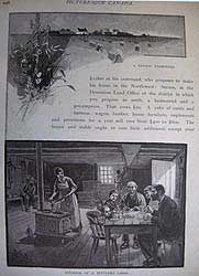
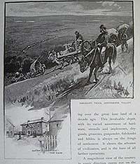
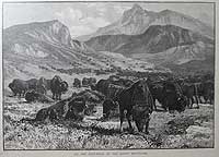
Prior to the early 1870’s, there were virtually no settlements in the North West Territories or Rupert’s Land save for a few scattered missions and H.B.C. posts. (see map item 11) Rather than turn to an agricultural existence in the Red River Settlement, many Métis decided to follow the disappearing buffalo herds into the North West Territory, (see item 10) returning each winter to temporary settlements along the North and South Saskatchewan rivers and in the Qu’Appelle Valley.  Following the insurrection in the Red River Settlement, the permanent Métis settlements of St. Albert (1866) and St. Laurent (1871) were founded. By 1873 the latter, named Grandin, had established a successful form of self-government under Gabrielle Dumont.

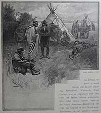
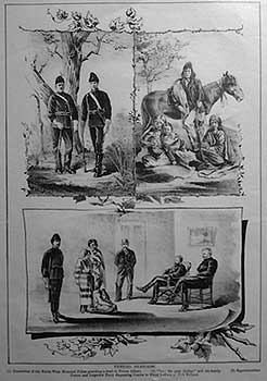
Development in the Canadian Northwest, while slower than that of the northwestern United States, was achieved without the humiliating spectacle of the Indian wars that have stained the history of U.S. expansionism. This was partly as a result of the respect gained by Indians, half-breeds and whites alike for the peace keeping efforts of N.W.M.P. (see item 12) A job made more difficult for the presence amid the Blackfeet and Cree Indians of Sitting Bull and his Sioux Indians, who had migrated to Canada following the battle of the Little Big Horn (25 June 1876). There they were joined by survivors of Chief Joseph’s Nez Percé War (1879). That peace and good relations were maintained in Canada was due largely to the enlightened presence of Assistant Commissioner Maj. James F. MacLeod and his 150 officers.

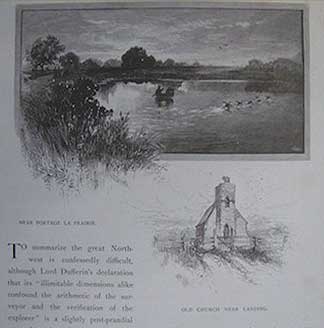
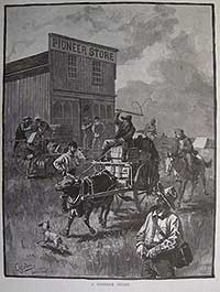
White settlement of the Northwest also developed around missions, such as at Prince Albert’s Presbyterian mission (1866); Hudson’s Bay forts, such as Fort Edmonton (1846); Telegraph line stations, such as Battleford, the surveyor’s headquarters and by 1877 the capital of the North West Territories; and N.W.M.P. posts, such as Fort Calgary (1875). Settlement was also stimulated by the rapid growth of the Canadian Pacific Railway towards the west in the 1880’s. The decision to take the southern route resulted in the capital of the North West Territories being transferred to Regina (Originally Oskana ka-asasteki/Pile of bones), in 1883, the site being selected by H.R.H. the Princess Louise, wife of Gov. Gen. The Marquis of Lorne. The year before, the territories had been divided into four provisional districts to facilitate the postal service.

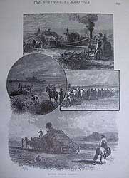
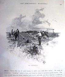
The challenge of opening up the west brought development and prosperity for the white man (see item 9) but spelled disaster for the Indians and near extinction for the buffalo (see item 10). The repeating rifle and pot hunting gave impetus to wholesale slaughter. The resulting disappearance in the early 1880’s of the buffalo meant dependence on charity, in time of need and abject starvation for many Indians, Métis and half breeds. Charity had been officially denied them by the Ottawa government in an effort to persuade them to remain on their reserves.

Treaties confining the free-roaming hunters of the plains to reserves, proved very disagreeable and an infringement of their liberty and ancestral way of life. Factors which readily fomented dissent and gave Louis Riel the following he needed. He answered the call of his people from Montana, where he had been living with his family since 1879, and was escorted to Batoche by Dumont in June 1884.

Win9a Emmigrant train Win9b Pioneer Store

9. EMIGRANT TRAIN, ASSINEBOINE VALLEY/FACTOR RESIDENCE, FORT ELLICE/ A PIONEER STORE/
Three wood engraved lithographs.  Published in Munro Grant. Picturesque  Canada 1882.
8 x 6 3/8" & 8 5/8 x 6 3/8" (20.4 x 16.2 & 21.9 x16.2 cm.) 
Ref. LRA72/-/r.dosl>AAL     PRICE CODE B

Three iconic views on two pages depicting life in the North West Territories. This area was being homesteaded in the early 1880's and both the H.B.C. trading post and the pioneer store serviced the long winding trains of pioneers, freighter's wagons and Red River carts plying their way toward a new, if difficult, future and the expansion of Canada.  The eerie screech of the un-greased axles of the Red River carts was heard for many miles across the Prairie heralding the new era.

Win 10a half breed camp Win10bbuffalo

10. HALF BREED CAMP / AT THE FOOTHILLS OF THE ROCKY MOUNTAINS
Two wood engraved lithographs.  Published in Munro Grant. Picturesque  Canada 1882.
7 5/8 x 6 5/8" & 6 5/8 x 9" (19.4 x 16.8 & 16.8 x 22.8 cm.)
Ref. LRA73/-/r.dosl>AAL       PRICE CODE B

 Two more iconic images of the North West, a double-sided view of a typical travelling camp of the half breed and Métis people who having sold (usually for a pittance) their scrip to a developer, were now on the move north west.  They largely just wanted to live in peace and at one with the land (despite the adoption of the cast iron cooking pot and the Red River Cart) as their forbears had done. On the reverse is a fine view of the once plentiful herds of North American Bison or Buffalo on whom the Métis culture largely depended. It is believed that the bison once numbered about 60 million. Wanton, systematic extermination at the instigation of the white man over a 15 year period reduced their numbers to less than 1000 throughout the continent - despicable carnage, and we call ourselves civilized ! (Fortunately, more enlightened conservation in the following century brought their numbers back from near extinction.)

WiniiMap Manitoba

11.  WESTMACOTT - MANITOBA & NORTH WEST TERRITORY
PROVINCE OF MANITOBA AND PART OF THE DISTRICT OF KEEWATIN AND NORTH WEST TERRITORY SHEWING THE TOWNSHIPS & SETTLEMENTS TO 1876 

 Colour Lithograph Map. published by H. Beldon, Toronto 1876 [1878]  
 16 1/4 x 251/8" (41.2 x 63.8 cm.) 
Ref. LRA  Atlas 2 1229/AN/g.door>RLL     PRICE CODE B

A splendid and decorative map depicting the Province of Manitoba and North West Territory, showing the townships and settlements, mounted police posts and Dawson Route to Winnipeg,  the Red River cart trail to the North West Territory, CPR only as far as Livingstone, post offices, forts, churches and mills, topographical features, Indian  reserves and tribal areas ceded and surveyed areas.   The map is adorned with images of steam boats, bison, a railway engine, Indian settlements making it an attractive acquisition for any western collection. On the verso are depictions of houses in Northumberland County, Ont. including that of Dr. Herriman and Col. A.H.T. Williams  (who led the charge at Batoche)  in Port Hope. 

Win12 Typical sketches
12. TYPICAL SKETCHES
A. Constables of the NW Mounted police guarding the trail to Prince Albert B. Metis and his family C. Superintendent Cotton & Inspector Perry dispensing justice to Blood Indians at Fort McLeod.[sic.]

Three views + text. Stone lithographs, Canadian Pictorial & Illustrated War News  4 July 1885
13 5/8 x 9" (34.6 x 22.9 cm.) Ref. LRA.#75 WC24/-/s.dosl>DAN   PRICE CODE A

A composite of three scenes of North West Territory life, including Superintendent Cotton and Inspector Perry of the N.W.M.P. dispensing justice to Blood Indians at Fort McLeod. Text "History of Riel's second rebellion, and how it was Quelled" by T. Arnold Haultain on the verso. 

Within three months of the N.W.M.P. deploymnt as guardians of the Great Lone Land that comprised the North West Terriory, they had eliminated the illicit whisky trade amongst the Métis and Indians, something whch the U.S. authorities had been unable to achieve in their western regions in ten years. By example and self-discipline, the N.W.M.P. gained the respect of the native and settlers alike throughout the North West. However, their small detachments put them in an impossible position to contain the situation once the N.W. Rebellion began. Middleton's virtual refusal to avail himself of their expertise in handling the inhabitants and their knowledge was a mistake which probably lengthened the campaign.

Fort MacLeod was constructed on an island in Old Man's River during the rapidly approaching winter of 1874.  The N.W.M.P. troops laboured the cut logs and gumbo as the temperature dropped to -10°F. There followed an exciting number of years in and around the fort as the area was policed and settlers spread into the west. By 1877 the fort had its own saw mill and two stores. The fort became the center of a small community with a mixed culture social life. By 1879 however, the mood was beginning to change as starvation set in amid the surrounding Blackfoot Indians, the disappearance of the buffalo and the government that failed to live up to the terms of Treaty #7.

See also
Part I The Red River Settlement

Part III The North West Rebellion of 1885

© Darrell G. Leeson MMXIX