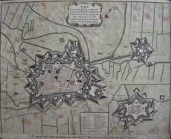
Plan of the city of AIRE and of FORT ST. FRANCIS with a view of St. Venant [inset]
Explanation, scale bar, Shows fortifications, topographical features, ordnance trajectory lines, redoubts, moats. Hand coloured Copper engraved plan. Basire eng.
The town was besieged in 1676 by Vauban and retaken for France, although it remained a Spanish possession until the 14th April 1713,when Aire [sur-la-lys] was returned to the kingdom of France by the Treaty of Utrecht in 1713. King Louis XIV gave permission to build a new and more prestigious Town Hall, in recognition of the suffering of the city during the siege of 1710 under Dutch occupation.
LRA 121/g.ln/ v. vo > ALN PRICE CODE B Click here for price code guide
Plan of the city of AIRE and of FORT ST. FRANCIS with a view of St. Venant [inset] Uncoloured.
LRA 114/O/ v. vo > DLN PRICE CODE A Click here for price code guide
