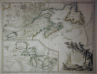
Inset: Supplement pour LES LACS DU CANADA
THIS IS THE FIRST EDITION, SECOND STATE of this significant
map.
Published in Gilles & Didier Robert de Vaugondy Atlas Universal.
Chez l'Auteur Paris 1758 [1786].
The map is dated 1755 and is considered an important map for
collectors of Canadiana.
Within the body of the map, Charleton Island is for the first
time named, and the orientation of F. de la Presqu'isle has been
changed. The height of land being the demarcation between Canada
and the Hudson Bay Co.
Fur trading routes, trading posts, forts & settlements along
river & lake connections may be seen, as can the French and
English fishing rites in Newfoundland, Acadian settlements and
native tribal territories, just prior to the French & Indian
war. 1755 was a significant year in the history of cartography.
John Mitchell's and Lewis Evans' maps were both published that
year along with various English and French maps which made territorial
claims for their countries.
The inset of the Great Lakes, shows a Bellin delineation complete
with the mythical islands in Lake Superior, invented by Bellin
in order that he might name them for his patrons, nevertheless
it is one of the finest delineations of the period and is one
of the earliest to use the present names of all five lakes.
This fine map is enhanced by a splendid title cartouche by C.
Haussard (Chaufrand) depicting a skin draped over a pine branch
and canoe, to the right of which lies a beaver, with a two story
beaver lodge in background.
The map is in excellent condition with full margins.
19 x 23
1/2" (48.3 X 59.7 cm.)


