Since 1763 the name 'Russborough' has been synonymous with collecting and dealing in fine art. Lord Russborough's Annex, specialises in an individual mix of antique maps, paintings and prints.

maps of canada

An extract of our maps currently available:
1600 - 1699 1 2

1700 - 1799 1 2 3 4 5 6 7 8 9 10 11 12

1800 - 1899 1 2 3 4 5 6 7 8 9 10 11 12 13 14

Antique map index

An extract of our rare antique maps pertaining to Canada and North America:


DESCRIPTION

PRICE CODE

Carver Quebec

A NEW MAP of the PROVINCE OF QUEBEC, according to the ROYAL PROCLAMATION of 7th October 1763...Service

Four insets

19 1/2 x 26"

Ref.DGL 406/ALN/dd.dnsn DANN

E
Click Here
for Pricing Details

Zatta Newfoundland

ZATTA- Newfoundland

Le Isole di Terra Nova e Capo Breton di Nuova projezione. Venezia 1778

Antonio Zatta

Plate Size 17 3/4 x 13 1/2" ( 45.1 x 34.3 cm.) Ref.LRA m1296 /DAN/ r.anan> ERN  SOLD

KITCHIN Cape Breton Is.

Map of Royal or Cape Breton I. from the best authotities.

Thomas Kitchin
6 3/8 x 4 1/16 " (16.2 x 10.3 cm) Ref. LRA dl273/AV.RN/dn.dovo>RGL

A vignette of a significant moment in Canadian maritime history.

Bellin J.N.
New France or Canada

LA NOUVELLE FRANCE OU CANADA
Scarce. Paris 1764 Original Hand tinting 7 ¾  x 13 ¾" (19.8 x 34.8 cm.)   

Ref. TM2/DNN/r.andg  ENN


DESCRIPTION

PRICE CODE

bouchette_toronto

Bouchette - Toronto, Canada

PLAN OF YORK HARBOUR

51/4 x 8 3/4" (13.5 x 22.5 cm.)

Ref. RPH18(193)/LNN/l.anad>OLN


D
Click
Here
for
Pricing Details

Click here for full description

War of 1812

WALKER War of 1812

UNITED STATES OF AMERICA exhibiting the seat of war on the CANADIAN FRONTIER from 1812 -1815
 inset : Chart of LAKES ERIE & ONTARIO on an enlarged scale

R. Walker engraver.    Edw. Baines, Leeds, 1816
 SCARCE Hand coloured, Copper engraved map Scale bars

 9 1/2 x 13 1/2” ( 24.1 x 34.3  cm.) 

 Ref. PS6/DLN/ s.nl > REL          

SOLD
B
Click
Here
for
Pricing Details

Click here for full description


Moll Atlantic provinces

MOLL.  ATLANTIC PROVINCES

NEWFOUNDLAND/ St LAURENS BAY,/ the fishing banks, /Acadia, and part of New / Scotland

Hermann Moll, Geographer [London] 1729
FIRST  STATE  outline colour. Scale of English miles. Note on treaty of Utrecht. 
7 ¾ x 10 ½”  (19.9 x 26.8 cm.)
Ref. DG1 /DLN/ s.ns > EOL    


DESCRIPTION

PRICE CODE

Click here for full description

Tallis Can West

TALLIS.  ONTARIO

WEST CANADA

J. Rapkin,  [London Ca 1851
SECOND STATE  Steel engraved, outline colour. Scale bar. 5 Vignettes

9 14/16  x 12 14/16 ”  (25 x 32.5 cm.)   

Ref. LRA map1249/OL/ 4.nn > RNN

B
Click Here
for Pricing Details

Click here for larger image

Homann Heirs Halifax Que ,Lou


HOMANN HEIRS - SEVEN YEARS WAR
VORSTELLUNG einiger Gegenden und Plaetze in NORD- AMERICA unter Franczoesisch  und Englische Jurisdiction gehoerig zu finden bey den Homaennischen Erben in Nurnberg Ao. 1756.

 Homann Heirs  Nürnberg 1756 [1762]

Scarce, Three plans and inset on one sheet, original colour, good margins.

17 1/2  x 19 1/2" (44.5 x 49.5 cm.)

Ref. BD3/DVNN/ v.anno >AANN

Winnipeg fonseca

FONSECA- Winnipeg
WINNIPEG 1884
W.G.Fonseca   Mortimer & Co.    Ottawa, 1884
 Colour Lithograph 29 x 391/2"  (73.5 x 100.5 cm)

Ref. LRA934/ENN/dd.sa > DOLN

click for larger image


DESCRIPTION

PRICE CODE

Click here for full description

de vaugondy Gt Lakes small

Didier Robert De Vaugondy GREAT LAKES

LES LACS DU CANADA/ et /NOUVELLE ANGLETERRE

Sr.Robert de Vaugondy,  [Paris] 1749
SECOND STATE  Hand coloured Copper engraving.

6 7/16  x 8 7/16 ”  (16.3 x 21.6 cm.)   

Ref. JdeC
1/AVL/ o.anno> LAL

SOLD
C

Click Here
for Pricing Details

DeL'Isle Canada1718

Guillaume DeL’Isle - Canada

CARTE  DU CANADA ou del la NOUVELLE FRANCE et des Decouveres qui y ont été faites.

19 5/8 x 25 ½" (50 x 65.5 cm.) 

Ref. PdeA1/SLN/ r.anda > DLNN

Click for enlargement

ThompsonCan&NS 1814Click here for enlargement

John Thompson & Co.

  CANADA and NOVA SCOTIA

No.34 [1814]

Original outline and body colour.  Glazed, Black & gilt-wood frame  19 x 23 ¼”(48.3 x 59.1cm.)  Frame 22 ½ x 30"
Ref. PR 2 (183)/DVL/ s.ando> EAL   

SOLD
B
Click
Here
for
Pricing Details


DESCRIPTION

Tallis Set of 4 canadian maps

Click here for enlargement

TALLIS – Maps of Canada

SET OF FOUR MAPS OF CANADA
British America
West Canada
East Canada and New Brunswick
Newfoundland and Nova Scotia

J. Rapkin London [1849-1851]

Beautifully hand tinted steel engraved maps, decorative  vignettes, Scale bar, Matted, Glazed, silver-gilt wood frames 

Maps: Approx 10 x 13"  (25.1 x 32.4 cm.)   Frames:  14 7/8 x 17 7/8"

Ref. LRAM 1295/ELN/d.andl> DLNN PRICE CODE E  SOLD

Another Set see images above

TALLIS – Maps of Canada

SET OF FOUR MAPS OF CANADA

British America  vignette: Montreal
Canada West vignette: Niagara Falls
East Canada
vignette: Quebec City
Nova Scotia & Nfld.
vignette: Halifax

Double Matted, Glazed, Framed. Each 17 x 21"

Ref. PR3 (183)/LNN/s.ando >DLOL PRICE CODE F


DESCRIPTION

PRICE CODE

Crutchley 1867 NE Us & Uppr Can

G.F. CRUTCHLEY-Eastern N. America

UNITED STATES (EAST ) WITH UPPER AND LOWER CANADA

Hand tinted  copper engraved map,  double matted,  glazed, Ornate gilt-wood and plaster frame. Map: 18 1/4 x 13 3/4" (47.6 x 34.9 cm.)   Frame: 23 1/2  x 19 1/2"

Ref. TM3/ DAL/ r.andg >RAL


SOLD
B
Click Here
for Pricing Details

goad Toronto1884

Click for enlargement

A plate from the First Fire Insurance Survey of Toronto of the Victorian era. 1884

Charles Edward Goad.

17 1/4 x 25 3/4" (43.8 x 68 cm.)   Ref. LRA1167 /SN/ d.dosv >EOL

JEFFERYS/BELLIN

A NEW CHART OF THE COAST OF NEW ENGLAND , NOVA SCOTIA ,  NEW FRANCE....

After Jacques Nicholas Bellin

Gentleman's magazine London 1746    13 3/8 x 18 ½" (34 x 47 cm.) Ref.SmacD1(194)/RNN/v.anad> GOL 

Torbett Louisbourg

TORBETT

PLAN OF THE TOWN OF LOUISBOURG

Torbett sculpt. for Haliburton's Historical and Statistical account of Nova Scotia 1829
4 x 61/2"
SmacD2(184)GL/v.anad>DRL


DESCRIPTION

PRICE CODE

GRde Vaugondy Gt lakes

Gilles Robert De Vaugondy - Canada and the Great Lakes

CANADA PARTIE DE L'AMÉRIQUE SEPTENT?
Paris 1755 [1758]

FIRST EDITION, SECOND STATE.
Original outline colour, title cartouche, excellent condition.
19 x 23 1/2" (48.3 X 59.7 cm.)

Ref. LRA M1263/VLN/l.anna RDNN

SOLD
G
Click Here
for Pricing Details

Coronelli Eastern canada

Coronelli - Canada

CANADA ORINETALE NELL'AMERICA SEPTENTRIONALE 1695,

17 3/4" x 23 3/4"

Ref:DRLN>DSVL

De Vaugondy Canada Small

Robert de Vaugondy - Canada

A/ NEW MAP OF CANADA

/Also/ the North parts of /NEW ENGLAND and NEW YORK; /with NOVA SCOTIA and/ NEWFOUND  LAND/From the Sr. Robert with Improvements.
Inset: Supplement for the Great Lakes of Canada

8 x 11 1/2" (20.3 x 29.3cm.)

Ref. LRA M.1260/ANN/s.nd   LLN

Bellin J.N.
New France or Canada

LA NOUVELLE FRANCE OU CANADA
Scarce. Paris 1764 Original Hand tinting 7 ¾  x 13 ¾" (19.8 x 34.8 cm.)   

Ref. TM2/DNN/r.andg  ENN

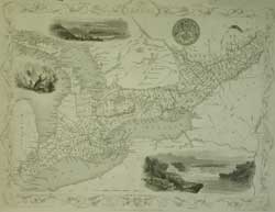
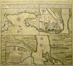
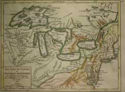
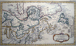
A fine example of Canadian Cartography

Logan Geological maps

A. MURRAY & Sir W. LOGAN

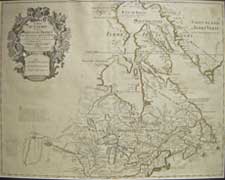
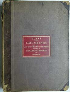
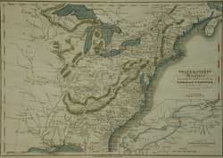
PLANS of various  LAKES and RIVERS between LAKE HURON AND THE RIVER OTTAWA., to accompany the GEOLOGICAL REPORTS for 1853-54-55-56.  

 Ref. SS3/ELN/  >DNNN   PRICE CODE D
4to. Original quarter calf and book cloth binding with red morocco and gilt label on f. cover. Published John Lovell,.Toronto 1857

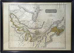
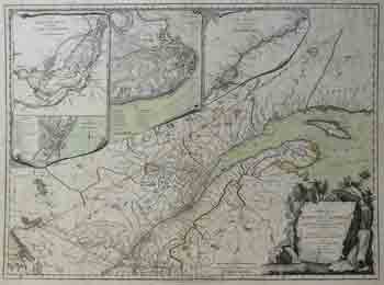
Drawn under the direction of Sir William E. Logan, Director of the Canadian Geological survey. 21 [of 22] delicately hand tinted plans are examples of early Canadian cartography and record the first Canadian expedition to explore, detail and map  the region. Numerous fascinating topographical and geological notes abound,including dips strikes and soil conditions and rock type.  Each folding sheet (approx. 23 1/4 x 36 1/2")  printed on thin government issue paper so there is some browning and some of the plans have tears along the folds with the passage of time.  Overall the condition is fair to good and clean inside. The binding is rubbed with section of the spine lacking, but Lovell's original binder's label is intact.
Contents:
10 [ of 11] Plans shewing Explorations on the North shore of Lake Huron and thence eastward to the Ottawa.
 7 Plans shewing explorations  between the east shore of Lake Huron and the Ottawa River.
 4 Plans of Bonne-Chere, Madawaska and Shawashkong rivers and sources of the Ottonabee.

Alexander Murray was the assistant provincial geologist under Sir William E. Logan (1798-1875) The first director of the Canadian Geological survey and for whom Mt. Logan is named.


This volume is a real find for those interested in Canadian cartography.