 |
 |
 |
 |
 |
 |
 |
Ocean, wherein the whale swims minnow-small. W. R. Benét
SECTION 4 THE SEARCH FOR THE RIGHT WHALE
- THE STORY OF THE EARLY ARCTIC WHALE FISHERY
From the age of the Vikings, sailors in Northern waters had been taking whales to supplement their meaghe Right Wahaler diet and to provide oil for their lamps. It is therefore surprising to learn that it was not until John Hunter, writing in 1797, that the first proper anatomical description of a Greenland Right Whale or Bowhead was published.
The Greenland whale fishery began in 1611 when, following in the wake of the Basque fishermen/whalers who had perfected the method of whale capture and of rendering byproducts in the Newfoundland and Labrador waters, the Dutch developed and eventually monopolized the flourishing trade based on Spitsbergen/Spitzbergen. Both the British Muscovy Co., who based their rights on Hudson's 1607 voyage and the Dutch who based their rights on Barents' 1596 voyage, claimed a monopoly of the island.
The British outfitted their first whaling vessel, the 35-ton barque "Grace", in 1595. The commercial ventures of the Muscovy Company were never really successful, in spite of Biscayan whalers' assistance and Baffin's enthusiastic endorsement following his 1616 voyage. The trade petered out in 1625 due largely to the incursions of rabiators, interlopers and freebooters, of many European countries including England itself, not to mention those seeking *‘quæstuary’. Further, the lack of regular supplies and naval support (due to the Civil War in England) gave the Dutch the opportunity to establish a formidable presence at Blubbertown/Smeerenburg, Amsterdam Island, N.W.Svalbard archipelago, amounting to a virtual monopoly of the trade. Operating from their bases on Spitsbergen and, later, Disco Island, the Dutch whalers were dominant for the next hundred years. Taking an average of four and a half whales for each ship in their fleet of 131 in the 1730's. By 1736 the Right whales were becoming scarce and land-based techniques obsolete as on-ship methods of processing were developed. The rape of the waters of Spitsbergen was complete. The exploitation of the island's land resources began a new era, heralded by the arrival of Russian ‘Lodias’ carrying settlers.
To combat the high price of oil [sounds familiar!], the British again began to develop their own fishery between 1711- 60, at which time they had a fleet of 35 ships. By 1788 their numbers had risen to 247 ships, and the British Arctic Whaling Fleet experienced its golden years between 1780-1824. In 1823 alone, 2,000 whales were taken. Their specially strengthened ships pursued the whales right into the pack ice on voyages lasting 5-8 months, until the Right whale became scarce also in Western Greenland waters due to over fishing. [also sounds familiar.]
*delightfully archaic word for profit
|
 |
 |
 |
 |
 |
 |
 |
 |
 |
 |
 |
The Americans, meanwhile, had not been idle, developing a Sperm oil fishery using sloop-rigged ships out of Nantucket and barque-rigged out of New Bedford and other New England ports. They became dominant in the market during the nineteenth century, by which time they had to sail vast distances (eventually to the South seas or the Pacific) in pursuit of their quarry.
The eighteenth century whalers sought principally two families of large whales, since the Norquales, capable of swimming at 12-15 knots, were too fast for most small boats. The first group the Greenland Right and Black Right or Bowhead whales, (Balæna glacialis) from their blubber 'train' oil for lubrication was rendered and mouth baleen or whale bone was extracted: the possessor of many a trim-corseted figure within the Court of St. James or The Hague was unaware of the incredible hardships endured by the whalers to facilitate her beauty. Named 'Right', because these were the correct whales to hunt since their slow speed enabled the catchers to get up close and, when killed, their crangs (carcass) did not sink - these features contributed to their being hunted to the brink of extinction. The other main species was the Cachalot or Sperm Whale, (Physeter catodon) from which ‘sperm’ oil, ‘spermaceti’ (the basis of cosmetics) and valuable ‘ambergris’ (perfume base) were rendered. One Greenland Right whale could yield 9 ½ tons of train oil, valued at £900 and 1½ tons of baleen, valued at £4,500 [-at the 18th.century value of the pound]. The number of whales taken throughout the 18th. Century was still minute compared to the wholesale slaughter of tens of thousands annually a century and a half later, when the value extracted from a single whale rose to as much as $10,000.
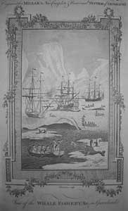
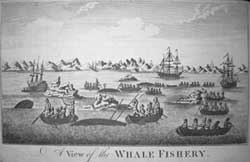
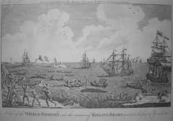
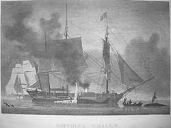
Eighteenth century participants in the killing game sailed to the hunt in slow, creaking, putrid smelling, wooden sailing vessels into the often viciously elemental Arctic waters around Greenland. The stench of whaling vessels could be detected miles away. Mariners had learned to navigate there by bitter experience, still using only crude instruments and charts to guide them through the fog and iceberg infested waters at the edge of the pack ice. Below deck the crew hands lived in appalling conditions. Having chanced upon a slow moving school of whales, the catchers or shallops, each generally containing seven flimsily clad men, were lowered and rowed to within a few feet of the leviathans. The harpooner would hurl a harpoon or iron with a line attached into one unfortunate beast before it dived in an effort to escape, thereby towing the frail boat at high speed through the water. (referred to by the American Whalers as a ‘Nantucket Sleighride’) When the whale began to tire, the harpooner and the coxswain changed places and the pitching boat was drawn in close. The coxswain then attempted the kill, using a lance thrust into the heart. In its death agony or flurry, the whale thrashed the water with body, fluke and fin, often smashing the fragile boat and pitching the crew into the blood stained frigid water, where death from hypothermia was the usual fate unless rescue was close at hand. Then began the arduous task of towing the whale back to the ship where it was secured alongside. Strips of blubber were removed, along with the baleen and head, or ‘junk piece’ in the case of Sperm whales by men climbing on its back or suspended on a makeshift cutting stage. The oil was rendered in huge iron Try pots of boiling blubber on a brick furnace which stood on sand ballast amidships, posing a considerable risk of fire on a rolling ship. The high profits financed more ships in spite of the risks and losses - such as the 19 ships from Hull crushed by ice on 19 June 1830, which left 1,000 men stranded on the sea ice of Melville Bay.
Although whalers rarely published charts due to the secrecy of their fishing grounds, they did contribute to the exploration of Baffin Bay, and the information they gathered regarding the coast and islands was eventually disseminated and appeared on later maps. Indeed, Captain Johnson in the 'Cumbrian' was the first to report that Lancaster Sound was open to the west, his ship arrived back in Hull in September 1820, a month prior to Parry's return. It was Johnson's fleet of six vessels that was probably the first to adopt what later became the favoured anti-clockwise whaling course around Baffin Bay, pioneered by Ross.
|
 |
 |
 |
 |
 |
 |
 |
 |
 |
 |
 |
What was the relevance of the Whale Fishery:
- The coasts and islands of Baffin Bay were explored and later charted.
- Scientific knowledge of whales gained from subsistence and later factory ship whaling.
- The basis of early cosmetics, perfume products and ingredient of margarine
- The use of fenks (discarded whale blubber) for fertilizer
- The formation of The International Whaling Commission
- Greater respect for Marine mammals especially from Conservation groups
- Food for northern communities and Asian markets.
|
 |
 |
 |
 |
 |
 |
 |
 |
 |
 |
 |
PLEASE NOTE THAT THESE ITEMS MAY ONLY BE PURCHASED AS A COMPLETE SECTION
Nine Items >SREL PRICE CODE J Contact us
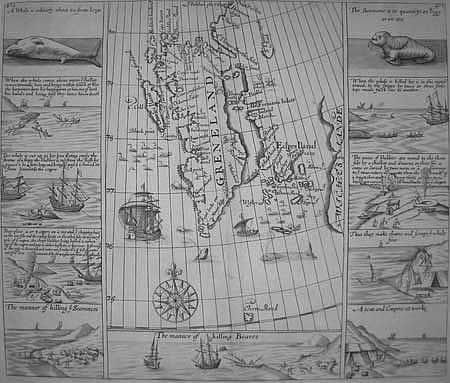
Purchas - Spitzbergen & Whaling industry
[GRENELAND, Edges Iland, Wiches Land
8 Whaling, 2 Seahorse, 1 Polar bear vignette panels]
[Samuel Purchas] [London 1625]
RARE Original copper engraving on laid paper 11 ½ x 13 ¼ " (29.2 x 33.7 cm.)
Ref.LRA1153/RVG/g.dosg > [DENN]
A rare untitled map, uncoloured as issued the main land mass of which is confusingly labeled Greneland [sic] but is in fact a depiction of Spitsbergen or Newland, as it was also known during the first quarter of the seventeenth century. Published in Purchas his Pilgrimes part III p.472/3 London 1625. The map also appears in Edward Pelham God's Power and Providence London 1631. Discovered by the Dutch just 29 years before the publication of this map was delineated, Spitsbergen,as it was known to the British during the reign of James the First and coincides with the end of the short period of domination of the whaling industry by the Muscovy Company of London, and its Govenor Sir Thomas Smyth (who’s name is enshrined in the toponymy) for whom this map was compiled. It derives partially from observations made by Henry Hudson, master of the Hopewell, sailing in 1607 on his first arctic voyage seeking a N.E. passage to China, and those of captain Thomas Edge of the Muscovy Company, who commanded ten arctic voyages between 1610-20. As reflected in the coastal place names, the main interest in these islands was as a base for whaling operations and harvest of other sea mammals, rather than for settlement.
Due to the lack of British naval support and proper commercial organization the emergent Dutch commercial whaling fleet gradually expelled the British from their seventeenth century whaling base, as the latter were also being driven from the Spice Islands.
Numerous 18th & 19th century whaling expeditions including those of William Scorsby's senior & junior, (inventor of the Crow's nest and pioneers in ice navigation) in the first quarter of the nineteenth century, added greatly to the knowledge of the coastal configurations. Nevertheless, Spitsbergen, or Svalbard as it is known today, was not circumnavigated until Carlsen's voyage of 1863. The Sir Martin Conway expedition of 1896-7 was the first to traverse the interior.
 |
 |
|
 |
 |
 |
 |
 |
 |
 |
 |
 |
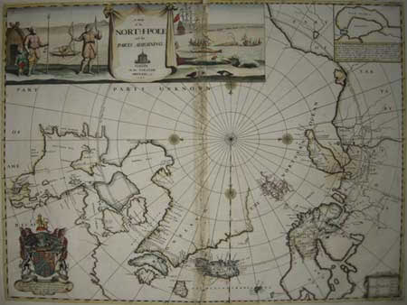
Moses Pitt - Polar regions
A MAP OF THE NORTH-POLE AND THE PARTS ADIOINING [sic]
M[oses]Pitt. Oxon at the Theater. MDCLXXX [1680]
SCARCE. First State. Original hand tinted copper engraved map on laid paper. Title vignettes and armorial dedication. Insets: Nova Zembla, lettered key. Slight separation along center cease where old tape removed.
18 x 22 7/8” ( 45.7 x 58.1cm.) Ref. LRA1210/ANNN/ dn.doso> [EDNN]
This is the only map drawn by Pitt that was published in Moses Pitt in the English Atlas, Volume 1, Number 3. Description of the places next to the North Pole; Oxford 1680. It is considered one of the most attractive English maps of the North Pole and Arctic regions. North Polar regions are depicted delineating settlements in Greenland, present day Spitzbergen, northern Scandinavia, Iceland, Russia and the mythical island of Freesland [sic]. In Canada where Baffin’s, Button’s and Hudson’s bays are named, marking numerous topographical discoveries from the voyages of Henry Hudson (1610-11), Thomas Button 1612-13, Robert Bylot and William Baffin (1616) who were the first to reckon Longitude at sea and take accurate tidal observations in Hudson Bay, they concluded that there was no Northwest passage from that bay. Beyond the west coast of the bays the region was then unknown to European explorers. This is a significant map of the region illuminated by coloured vignettes of Inuit /Eskimo life, the whale fishery, indigenous birds and a full armorial bearing of Charles, Earl of Plymouth to whom the map is dedicated. An inset depicts Nova Zembla, prominent in the search for a Northeast passage. This fine map is enhanced by the original outline hand tinting. The glue line, where old tape was removed along the centerline and in the left border (the latter not affecting image), and the added numerical date could be improved by professional conservation.
Vide: Kershaw K. A. Early printed maps of Canada 1540- 1703 Entry 120 plate 78
|
 |
 |
 |
 |
 |
 |
 |
 |
 |
 |
 |
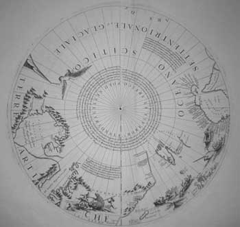
Coronelli - North Pole
[POLO SETTENTRIONALE O BOREALE ET ARTICO]
Vincenzo Maria Coronelli (Ca.1695)
Terrestrial Globe Gore Cap of the Arctic polar regions. Printed on an uncut sheet of laid paper from original copper plates. Published in Corso Geografico Universelle [Venice: Vincenzo Maria Coronelli 1691 (ca.1695)]
Full margins showing the plate mark. Cap:14 7/16 ” (36.7cm.) diameter. Sheet: 19 x 27 ¼”
Ref. LRA1157/GNO/ o.dnsg> DGLN
A Fine Terrestrial Globe Gore Cap/Calotte of the Arctic polar regions by the Venetian cosmographer Vincenzo Maria Coronelli and intended for a 110cm. terrestrial globe. Depicting the northern coasts of Canada, Greenland, Scandinavia and Siberia. The map is largely based on the Dutch maps of Jansson/Blaeu delineation of the Arctic, In Canada note the single waterway almost linking Hudson & Cumberland straits, a derivative garnered from Sanson. ‘Terra de Wiches’ appears east of Spitzbergen and the tip of Nova Zemla [sic] is joined to the mainland of Tartary (Russia) based on Visscher 's 1684 map.
As Royal Cartographer to King Louis XIV in the 1680s, mapmaker Vincenzo Coronelli gained special access to the most current records, and as Shirley reports “Coronelli seems to have sought to omit nothing that might be of interest to geographers, navigators and explorers. There are an unusual number of legends, all explanatory and informative, but which never crowd the space available.” Shirley
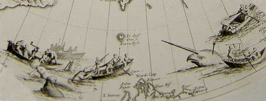
The Cap is decorated with pictorial vignettes, depicting polar bears being attacked with spears, seals with muskets, and whalers pursing Narwhals, in which encounters the animals appear to have the upper hand if ultimately collectively they have been driven to near extinction. Whilst taking pride in the accuracy of recent discoveries he seems to have been in error regarding those of Baffin in 1616, for Governor Sir Thomas Smyth/ Smith’s sound is shown as a bay together with Lancaster & Jones sounds, despite for a notation in the bay stating their discovery in 1623/24 (a year after Baffin’s death).
Vincenzo Maria Coronelli (1650-1718) was both cleric and encyclopedist, with a particular interest in geography and cartography. He joined the Franciscan Order in Venice in 1665 and six years later entered the convent of Santa Maria Gloriosa dei Frari, which was to become his professional workshop. He was sole author or contributor to over one hundred and forty titles and produced several hundred maps. Following his service for Louis XIV, Coronelli returned to Venice in 1684 and founded the "Accademia Cosmografica degli Argonauti," a geographical society with membership drawn from the aristocracy and church hierarchy, and a year later he was appointed Cosmographer to the Republic of Venice. With a secure financial base provided by the society, Coronelli could ensure that his maps would be widely dispersed across Europe. At the end of the seventeenth century, he was perhaps the most famous map publisher in Europe and received constant requests from his contemporaries for information that would enable them to bring their atlases up to date.
Vide: Ref. Kershaw K.A. Vol. I Entry 169 Plate 106
|
 |
 |
 |
 |
|
 |


