Since 1763 the name 'Russborough' has been synonymous with collecting and dealing in fine art. In the closing decades of the last century the historic town of Port Hope has become home to Lord Russborough's Annex, which specialises in an individual mix of antique maps, paintings and prints.

British Paintings in oil
An extract of our maps currently available:
Guiljelmo Blaeu - Arctic Regiones sub Polo Arctico
Matthius Quad Polus Arcticus

Gatonbe Harbour of Hope 1612

Ruscelli/Zeno North Atlantic 1599

The exploration of the Arctic and Northern Canada - Index

An extract of our rare antique maps pertaining to the Arctic:


DESCRIPTION

PRICE CODE

Guiljelmo Blaeu - Arctic Regiones sub Polo Arctico

First State - German Edition. coloured
16 1/4" x 21"

Ref: DRLN>DSVL


SOLD

F
Click Here
for Pricing Details

Matthias Quad

POLUS /ARCTICUS/ siue /tract, Sep/tentriona/lis. Coloniae, ex Officina Typographica Jani Bussemechers

 insets:Farre insulæ
             Schetlant insulæ
             Frisslant insula
SCARCE. Original copper engraved map on laid paper. Uncoloured as issued. Latin text on verso.p.81 good impression good condition and borders.

 8 3/8 x 10 7/8’“ (21.2 x 7.6 cm.)

 Ref. LRA1169/OLN/a.dosv> DONN

John Gatonbe
[the fashion of savages rowing in their boats 
together with
Wilkinson’s Islands, The Harbour of Hope, Mount Hatcliffe
and
Cunningham Mount]

Two original copper engraved plates in one on laid paper. Plate size 1: 7 7/8 x 5 1/2” , 2. 2 1/4 x5 1/2”  overall: 10 1/4 x 5 1/2” ( 26 x14 cm.)
Ref. LRApArc148/RN/ r.doss>ANN


DESCRIPTION

PRICE CODE

Zeno NAtlantic

Click here for enlargement

ONE OF THE GREAT APOCRYPHAL MAPS OF THE NORTH ATLANTIC

Ruscelli /Zeno Septentrionalium Partem Nova Tabula.

[1561(1599)]
Original copper- engraved map uncoloured as issued. Map: 7  x 9 3/8 " (17.8 x 23.8 cm.)  plate size 7 3/8 x 10 1/4  (18.5 x 26 cm.) From Book 4 Descrittione dell'America p.142 Italian text on verso.

Ref. DGL m827 /ALN/r.dosa >DGLN   


F
Click Here
for Pricing Details

A Collection of original antique maps and prints pertaining to
THE EXPLORATION OF
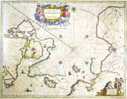
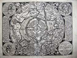
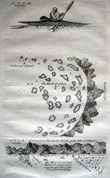
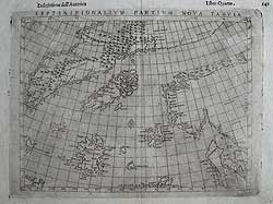
THE ARCTIC & NORTHERN CANADA


Arctic exploration im

    “We shall not cease from exploration     And the end of all our exploring
          Will be to arrive where we started    And know the place for the first time.”  T.S. Eliot

The maps pertaining to the Exploration of the Arctic are found in the following sections click on the index to see synopsis

INDEX

The Ellis map of the Moor & Smith voyage

The maps of Samuel Hearne

Maps pertaining to the Whale Fishery

Maps relating to the exploration of the Pacific Northwest: Section 5 6 7 8

Maps of Northern Canada: Section 2 8 9

Home
Location
Home | Contact | Location | Links | Antique Prints | Fine Art | Antique Maps | Omnium Gatherum | Specialty Services